
There have long been scholarly disputes within academic circles regarding the route and terminal point of the northeastern section of the Great Wall built by King Zhaoxiang of Qin during the Warring States Period. Synthesizing existing theories and combining historical documents, archaeological findings, the approximate location of the northern boundary of Shang Commandery around the 35th year of King Zhaoxiang’s reign, and the construction periods of the ancient Great Wall remains at the Xinjialiang(辛家梁) and Xinminbao(新民堡) sections, this paper infers the distribution route of the northeastern section. It is proposed that this section connected in the southwest to the Sujigou(速机沟) section of the Great Wall in Nuanshui Town(暖水乡), Jungar Banner, Inner Mongolia Autonomous Region. From there, it extends northeastward, passing through the mountains near Xiaoxigou(小西沟) at the source of Geqiugou(圪秋沟) and Hejiagou(贺家沟). Then, it meanders eastward along the watershed of the eastern part of Dongsheng Liang(东胜梁), and finally reaching the west bank of the Nalin River(纳林川), west of the Nalin Ancient City(纳林古城).
Currently, one township and eight li(administrative subdivisions,里) in Jiangling County during the reign of the Qin Dynasty have been discovered. Among them, the locations of one township and four li are clearly identified, and the affiliation of two li is clearly defined. From the Early Han Dynasty to the Early Reign of Emperor Wu, there were five townships and twelve li in Jiangling County. Among them, the locations of five townships and four li are clearly established, and the affiliation of nine li is clear, with Xixiang(Western Township) being the leading township. The Qin regime implemented name-change measures at the grassroots level in this region, but the implementation was incomplete in the Qin dynasty. The existence of a large number of scattered villages during the reigns of the Chu, Qin, and Han Dynasties indicates that none of the three regimes seemed to have any intention of strengthening grass-roots control by converting scattered villages into concentrated settlements. The economic situation of residents falls into two categories: ‘universal impoverishment’ and ‘wealth disparity but far from reaching general poverty’, and the latter is more common and typical. Through a case study of Jiangling County, we can not only deepen the study of the township system during the Qin and Han Dynasties but also help to develop a long-term investigation of the grassroots systems of the Chu, Qin, and Han Dynasties within a county-level framework.
Based on the mutual corroboration of unearthed epitaphs, transmitted documents and above-ground relics, this study reconfirms that the administrative seat of Luzhou(鲁州), the first of Liuhu Zhou(六胡州), was located in the old foundation site of Xingwu Forts(兴武营), Yanchi County(盐池县), and the ancient city ruins still exist. At the same time, the scale of the city of Luzhou belongs to a small state town or county seat, and it has the livelihood mode of herding city, and the Pastoral Supervisor in Shuofang(朔方监)may sojourn here to handle government affairs.
Based on local gazetteers and other historical documents, this paper empirically examines the correspondence between land temples(tudimiao) and settlements in eastern Zhejiang during the Ming and Qing dynasties. On this basis, it explores the phenomenon of temple branching—referred to as fenshe(subdivision of earth god associations, 分社)—and points out that the main reasons for this include settlement disputes and population growth. Furthermore, by calculating the ratio between settlements and religious facilities such as temples in eastern Zhejiang, the study concludes that folk beliefs in this region were more developed than those in the Jiangnan Delta.
Located on the border of Henan and Anhui provinces and adjacent to the Sha River, Jieshou was a commercial market town engaged mainly in transit trade during the traditional period. By the early Republic of China era, it was already acclaimed as the ‘foremost town in the county’. During the War of Resistance against Japan, Jieshou gathered a large influx of people and goods, and smuggling within its area became especially rampant, earning it the nickname ‘Little Shanghai’. This economic boom prompted adjustments in administrative structures. The three towns of Jieshou gradually separated from their parent county in terms of space and governance, forming a relatively loose union. However, because no formal administrative district was established, the town declined rapidly after the war. In 1947, Jieshou was designated as a city, and multiple measures were adopted to reverse its downturn. After 1949, the focus shifted toward economic reconstruction. Jieshou transformed from a point-like urban administrative unit—a ‘city’—into a regional administrative unit—a ‘county’—that encompassed rural areas, aligning with national policies aimed at building a new pattern of urban-rural development.
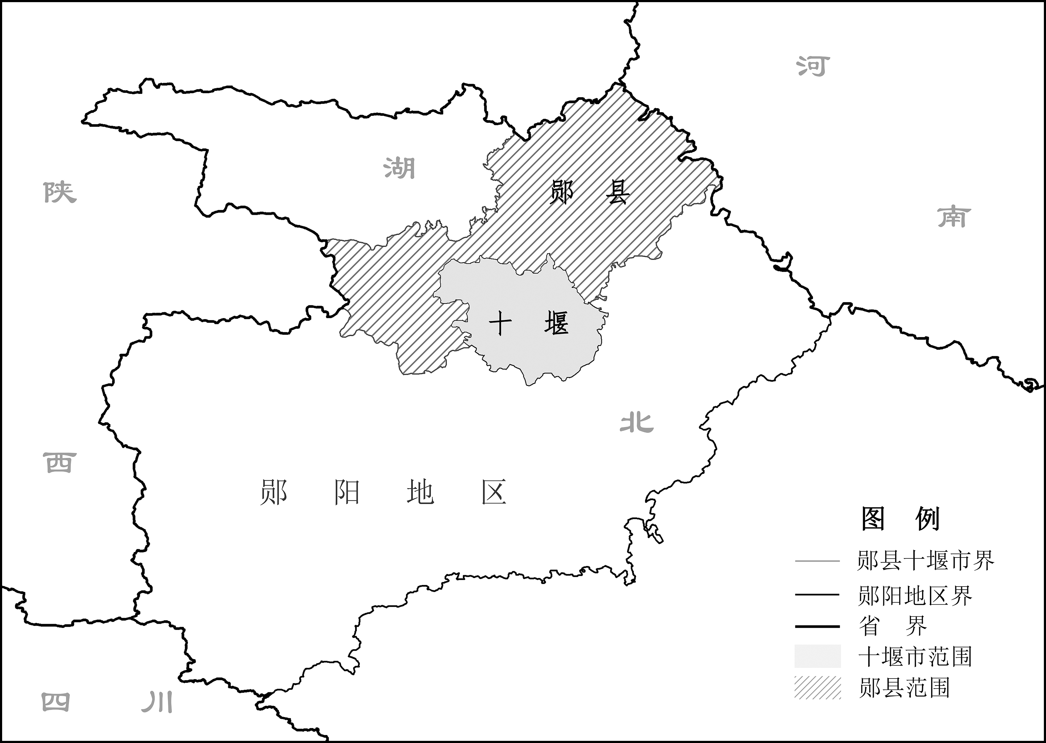
The administrative adjustments made during the ‘Third Front Construction’(三线建设) from the 1960s to the 1980s constitute a significant phase in China’s modern administrative history, laying a substantial foundation for large-scale rural urbanization. To better support the Third Front Construction, the central government established Shiyan City by separating it from Yun County(郧县) in Hubei Province. The formation of Shiyan during this period went through four stages: the unsuccessful proposal for an industrial district, the creation of a provisional non-incorporated administrative area, its establishment as a county-level city, and its eventual elevation to a province-administered city. This case represents an important and special example of administrative realignment after the founding of the People’s Republic of China. The administrative adjustments of Shiyan City(十堰) were driven by the evolving needs of different phases of the Third Front Construction, reflecting the multi-faceted interactions between the Second Automobile Works and local governments. This fully demonstrates the significance of well-timed administrative adjustments for the development of Third Front enterprises and the construction of Third Front cities.
The toponym ‘Bolor’ first appeared on European maps no later than the early 14th century, following the publication of Marco Polo’s accounts. However, for centuries thereafter, it was rarely used by European cartographers to denote a specific geographic entity. One early and explicit cartographic representation appears in Bellin’s 1749 map Carte de la Petite Bukharie et Pays Voisins, where ‘Bolor’ marks a mountain knot in Innermost Asia. By the 19th century, ‘Bolor’ was sometimes depicted as a meridional range that merged with Ptolemy’s north-south trending ‘Imaus’. With the advancement of Oriental studies and scientific expeditions, European scholars in the mid-19th century rediscovered ‘Bolor’ and linked it to Chinese classical toponyms such as ‘Po-lu-lo’ and ‘Bo-lü’, identifying its location near Gilgit, south of the Hindu Kush Mountains.

The Gough Map, as the earliest known surviving medieval map to depict the island of Britain in panorama, holds a significant position in the history of cartography. Since the 21st century, Western academic circles have carried out research on it by adopting such technical methods as image scanning and spectral technology, distortion grid and displacement vector analysis based on MapAnalyst, as well as regression analysis. The findings offer three key implications: First, the Gough Map shares more commonalities than differences with ancient Chinese maps, suggesting that these technical methods can be transferred and applied. Second, the study exemplifies the principle of ‘let the map speak for itself’, thoroughly excavating cartographic information to interpret socio-cultural landscapes. Third, it emphasizes the comprehensive application of diverse methodologies, combining material analysis, spatial quantification, and Historical GIS to construct a comprehensive research matrix.
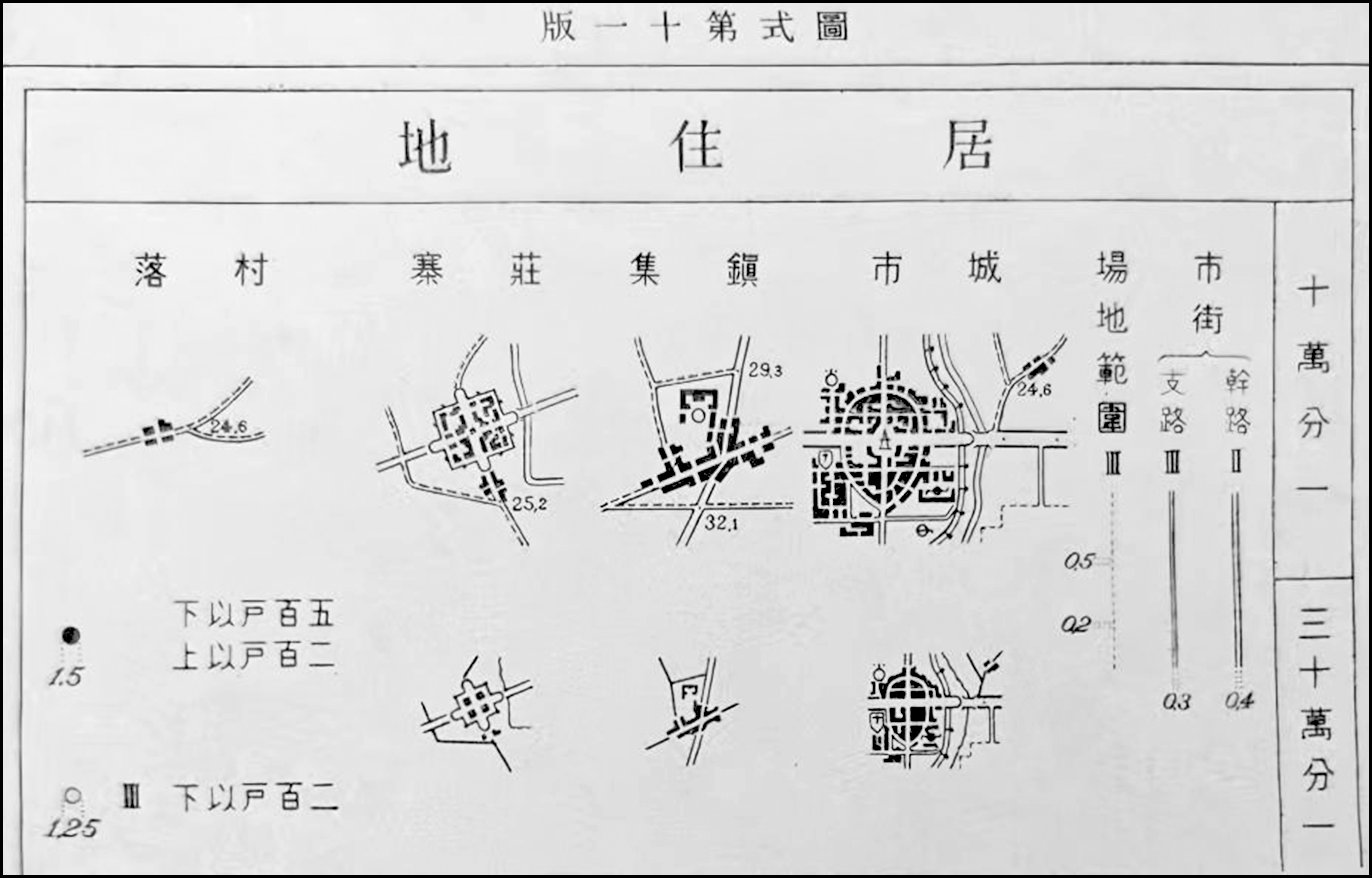
During the Republic of China period, the 1: 100 000-scale topographic maps marked urban and rural settlements in a clear hierarchical manner based on population thresholds of 10,000, 1,000, and 500 people. They also established a map symbol labeling system that included ‘true-form’(真形) representations, as well as the symbols ●, ☉, and 〇. This classification standard exhibited a significant discrepancy from actual conditions. Generally, settlements marked with ‘true-form’ can only be regarded as those with an obvious urban nature and a population of over 2,000. Settlements labeled with the symbol 〇 correspond to those with a distinct rural nature and a population of less than 500. The two symbols ● and ☉ should be consolidated, representing settlements with a population of 500 to 2,000 that primarily fall between the urban and rural categories.
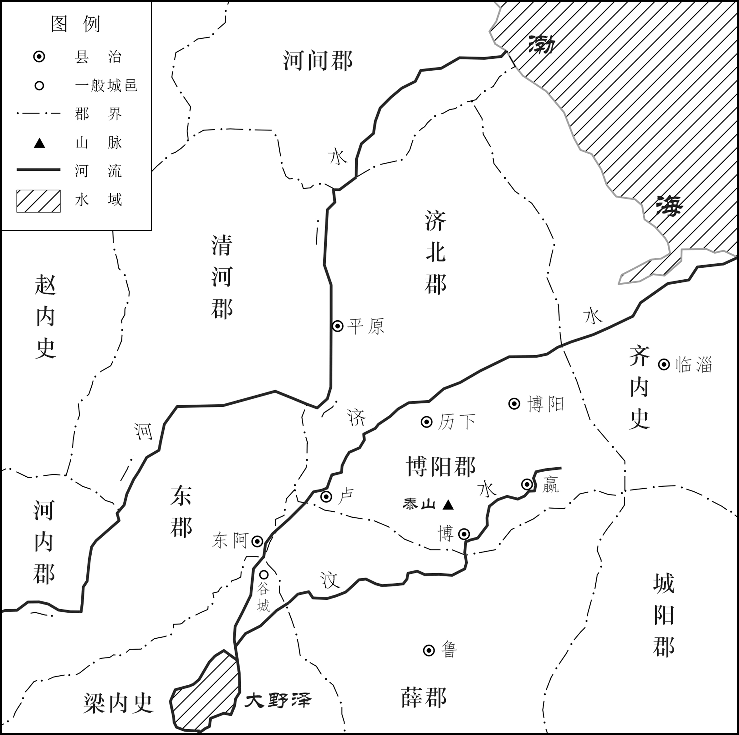
In the sixth year of Emperor Gaozu of the Han Dynasty, the former Qin Jibei Prefecture(秦济北郡), previously Tian An’s Jibei Kingdom(田安济北国), was divided, establishing Boyang Prefecture and Jibei Prefecture. Based on clay seals such as the ‘Seal of the Neishi of Lü’(吕内史印) and the ‘Seal of the Chief Palace Officer of Lü’(吕大官印) unearthed from the Han-period Luozhuang tomb(洛庄汉墓) in Shandong, as well as the record in The Table of Marquises of Royal Blood in the Book of Han(Hanshu Wangzihoubiao,《汉书·王子侯表》) that the Boyang(博阳) Marquis enfeoffed by Emperor Wu was located within Jinan Prefecture, it is evident that Boyang was situated in present-day Zhangqiu, Shandong. This was not the same location as the ancient Bo County, whose former territory falls within present-day Tai’an. By examining the relevant battles of the Chu-Han Contention, it can be seen that from the late Qin Dynasty to the early Han Dynasty, Jibei Prefecture and Taishan Prefecture(泰山郡) were bounded by the Ji River(济水), making the ‘name’ of Jibei consistent with the ‘reality’ of its geographical situation. Furthermore, Lu Prefecture(鲁郡) was established in the early Han Dynasty, which bordered Boyang Prefecture along the line between Lu and Bo, the border counties of the Qi Kingdom(齐国). The traditional view that Boyang Prefecture bordered Xue Prefecture(薛郡) along the Wen River also requires revision.
There is considerable controversy regarding the historical evolution and geographical location of the three counties—Liang, Qi, and Juan—in Henan County recorded on slip 456 of the Statutes and Ordinances of the Second Year Statutes on Ranks(《二年律令·秩律》) of the Zhangjiashan Han Bamboo slips. According to the pattern of counties in Henan County being listed from west to east in the ‘Statutes on Salaries’, Liang(梁) was located in the eastern part of Henan County, specifically at Daliang, the capital of the State of Wei during the Warring States period. This is a different place sharing the same name as the Liang in Henan County recorded in the administrative geography of the book of han. Similarly, Qi(岐) was also situated in eastern Henan County, at the present-day Xicheng Village(西城村) site north of Tongxu, Henan Province. Juan(卷) was closely linked to Hengyong. The original site of Juan was located at the modern Dongquan and Xiquan villages in Zhulou Township, Yuanyang(原阳县祝楼乡). It was later moved to the city of Hengyong(衡雍). As Juan was abolished in later times, the city of Hengyong came to be regarded in subsequent historical records as the site of Juan since its establishment, thereby conflating the relationship between Juan and Hengyong.
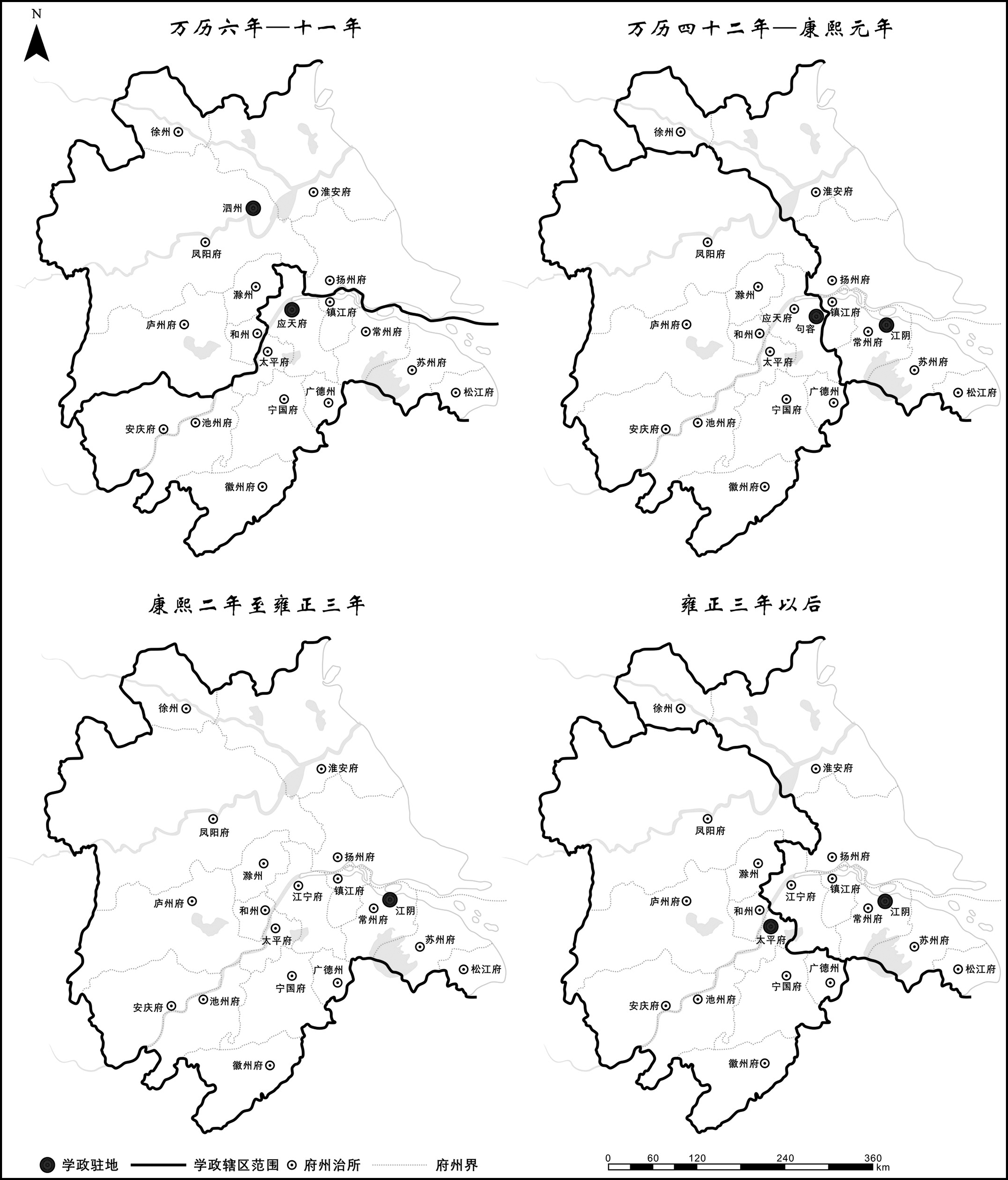
During the Ming and Qing dynasties, the official residences of provincial education commissioners were generally located in provincial capitals, though there were several exceptions. The Shuntian(顺天) education commissioner once resided in Yizhou, and from the Qianlong reign onward, the post was permanently stationed in the capital rather than Tongzhou(通州). The Shangjiang(上江) commissioner was based in Jurong; the Jiangsu commissioner in Jiangyin; and the Anhui commissioner in Dangtu(当涂)—each reflecting continual adjustments to their respective jurisdictions. The Shaanxi education commissioner resided in Sanyuan County(三原县), a placement linked to the influence of Nian Gengyao. In addition, the Zhejiang commissioner was once located in Jiaxing, the Shandong commissioner in Qingzhou(青州), and the Zhaogao(肇高) commissioner in Zhaoqing—all somewhat unusual cases.The site selection of these education commissioners’ residences was closely tied to the evolution of the education commissioner system, changes in administrative jurisdictions, and the locations of provincial examination halls. It was also affected by occasional factors such as the damage of official buildings, wars and chaos, and even the personal preferences of the governing authorities.
In the forty-seventh year of the Qianlong reign, due to the persistent failure to the breach at Qinglonggang(青龙岗) on the Yellow River, the proposal to alter the course of the river near Lanyang(兰阳) was initiated. This led to the relocation of the Kaocheng(考城) County seat northward and the adoption of a plan to use the river as a boundary, in response to the shifting of the river’s course southward and the resulting changes in the local administrative landscape. By the third month of the forty-eighth year of the Qianlong reign, as the new river course was completed, the counties of Kaocheng, Fengqiu(封丘), and Yangwu(阳武), which were separated from their respective prefectural seats by the Yellow River, were reassigned from Guide(归德) Prefecture and Kaifeng(开封) Prefecture to Weihui(卫辉) Prefecture and Huaiqing(怀庆) Prefecture, respectively, to facilitate unified river management. The reassignment of these three counties was formally completed by the end of that year at the latest.