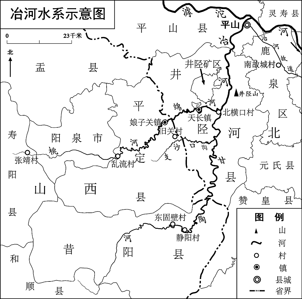
Tao River, which is recorded in the volume of Zhuozhang River of Notes to the Book of Rivers, was thought to be the current Tao River by many scholars through history, while Yan Gengwang argued that it should be Guguan River. However, there are discrepancies between the two opinions. Actually, the watercourse of the ancient Tao River include the watercourse of present Gantao River, Ye River and the ancient watercourse of Ye River. We thought the reason the current Tao River bears the name is that Cai Gui misunderstood Notes to the Book of Rivers.
The formation of sandbanks in the Lijiang River was a result of the interactions between natural environment and human activities. Since the Ming and Qing dynasties, people continuously flowed into the upper reaches of the Lijiang River to engage in agricultural work and land reclamation. They also reshaped the natural environment of the mountainous upstream area. The soil unearthed left from agricultural work and those carried by rainwater were then swept out into the Lijiang River, resulted in sediment, which accelerated the formation and development of sandbank, and shaped the appearance of the Lijiang river bed in Guilin city. The settlements were also transferred from the sandbars to sandbanks. The relationship between man and land in Lijiang River basin changed as thus.
Water conservancy map tablet is a special form of water conservancy materials. The spatial distribution of such tablets is quite dispersive though with a small amount overall. To some extent, the water conservancy monument reflects the history of a regional society, especially in areas where water resources are scarce. It is not only the epitomized expression of water right consciousness, but also the reflection of people's attitude towards water resources. It is also the result of people's consultation, negotiation, and confliction under water stress. Taking the water conservancy map tablets as clues, this paper further excavates the history of related people and events, with the aim to deepen and expand the existing social history researches of water conservancy. It will help to gain a deeper understanding of the role and influence of water in the historical changes of traditional Chinese rural society.
The evolution of traditional technology has complex socio-economic and environmental backgrounds. This paper aims to reveal the complexity of the evolution mechanism of sea salt production technology in ancient China, by discussing the development process of salt-making technology in Huainan saltworks and the influence of key restricting factors. In the late Ming and early Qing dynasties, methodologically, traditional decocted salt production of the sea saltworks in China were replaced with solar-salt production, while the traditional decocted salt way was kept in the Huainan saltworks of Jiangsu Province until early 20th century. This was a special phenomenon in the economic history of China's sea salt industry. It was due to sandy soil and less than 500 mm net evaporation in the central and southern Jiangsu coast, which limited the development of large-scale solar-salt production in this region. The policy support on marketing management policy made the Huainan traditional decocted salt production more consolidated in Qing Dynasty, and further restricted technological innovation. This study provides an example for the comparative study of pre-industrial technological evolution, and reflects the mechanism of indigenous technology development and local adaptability.

Based on new materials, this paper argues that the City of Ying was rebuilt alongside the old Jiangling City, after the Qin general Bai Qi's taken-over of Ying. Afterwards, both the Nanjun Prefecture and Jiangling County used this city as their seats. During the middle Western Han, the Nanjun Prefecture and Jiangling County relocated their seats to the newly built Xi'eshan City, and Ying City became the seat of Ying County. Since the end of Western Han, the Ying County was canceled and the city became a courier station, which lasted until the last era of Eastern Han. Later on, Guan Yu, Huan Wen, and Wang Chen, successively rebuilt the Jiangling City on the basis of the old Xi'eshan City. It is only after Huan Wen rebuilt the Jiangling City that the two cities Jiangling and Jingzhou merged. During the reign of Wude in the Tang, Nanjun Prefecture was canceled. At around the fourteenth year of the Tianbao reign, the Yangtze River changed its course to the south of modern Jingzhou City, therefore the Jiangling City was moved from Xi'eshan City to modern Jingzhou City and remained in the same place to this day.

Before the Yuanfeng's reign of the Northern Song Dynasty, the number and size of the townships changed with the growth and decline of the population, so the boundary was not stable. After Wang Anshi's reform, the administrative function of the township was hugely diminished, along with disappearance of the function of “township household”, and the boundary of township gradually stabilized. Rather than crossing boundary, the basic reforms like the Baojia law and the boundary law were completed within townships. Such policy provisions strengthened the integrity of the township, making the boundaries of rural areas clearer. According to the differences among the neighboring entities, the boundaries can be divided into four categories: boundary between the townships; demarcation of the administrative district between the town and the state army county; boundary between the township and the administrative office; and demarcation of a township and a town. The analyses based on existing material show that the demarcation of the townships generally follows the principle of “Shan Chuan Xing Bian”(mountain and river form), which is not only for the administrative convenience of grassroots officials, but also in line with the law of the formation of natural settlements.
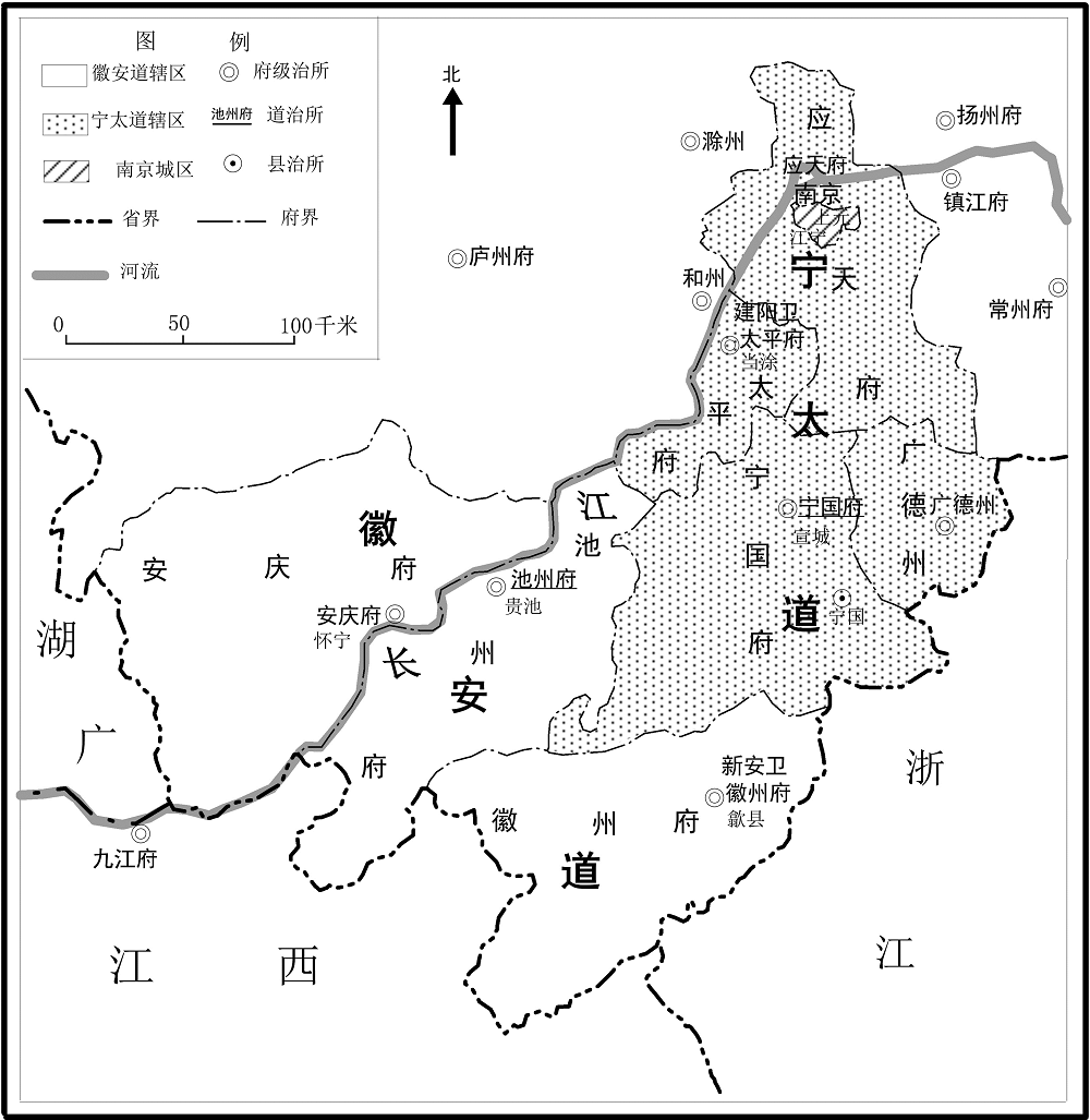
The Military Defence Circuit was an important local management institution in the Ming Dynasty. In order to contain the intrusion of “River thieves”, “Wokou” (Japanese pirates) and “Mining thief”, as well as to consolidate the local farming system, water conservancy, and other affairs, the Ming court successively established five Military Defence Circuits in Fengyang, Jiujiang, Taicang, Yingtian and Huirao from Hongzhi to Jiajing Reigns. Their scope of the jurisdiction cover both Anqing and Huizhou. During this period, the Military Defence Circuit's jurisdiction unit gradually changed from Wei to Fu (prefecture). In the sixth year of the Longqing Reign, out of the consideration of unifying administrative divisions, the Ming court set up the Huining Military Defence Circuit, which put Fu and Wei in Anqing and Huizhou under the same Military Defence Circuit's management, while remained under the jurisdiction of South Zhili. Later, due to changes in local situations, the Ming court made a series of differentiations and adjustments to the Huining Military Defence Circuit in order to keep it militarily advantageous. The evolution of the division and integration of the Military Defence Circuit shows the importance of local governance in Anqing, Huizhou areas. It would become one of the precursors to the formation of Anhui Province in the Qing Dynasty.
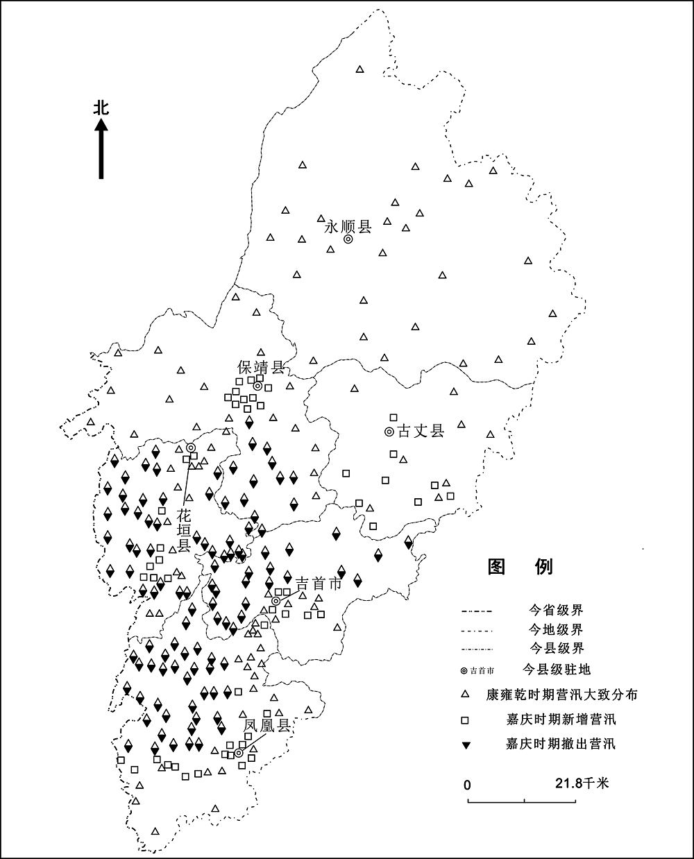
The Ying Xun system was the grassroots military system of local governance in Qing Dynasty, important to the local governance of Xiangxi Miaojiang. Although it was relatively stable after its formation, due to the ethnic population, natural and social environment, its establishment, withdrawal, improvement, and adjustment often transformed through the history. Thus, the characteristics of the Ying Xun system could be “changing by the trend”, which also reflected the integrating process of Xiangxi Miaojiang into the National “inland border”.
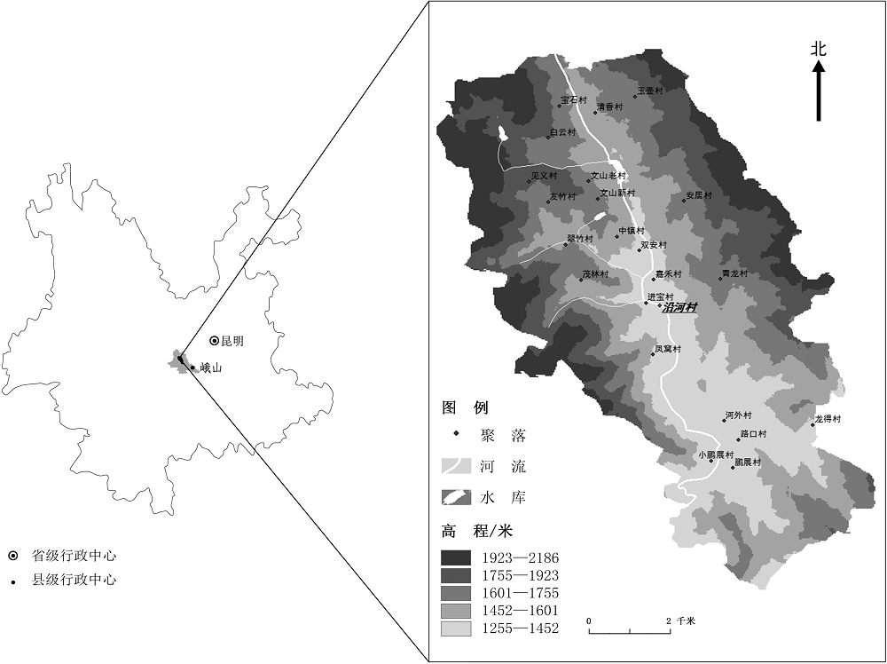
Reconstructing the temporal and spatial process of population change in mountainous settlements is a significant way to understand the population development in historical periods.Taking Yanhe village, a mountainous settlement in Southwest China, as an example, we estimated the whole number and average size of households, and reconstructed the population change process of the village in the past three hundred years mainly with fieldwork and document research.The number of households was converted on the basis of a proxy index, namely the number of marriageable men from the predominant generation at a given time point.We used the family structure model to calculate the average size of households according to the marriage, birth and death data of several villages in the basin.Then, we calculated an empirical value as a substitution, with the age composition data of 1953, and the average size of children and elderly per household in the basin, to reconstruct the average size of households before 1920.Therefore, a long-term average size of households was obtained.This method is meaningful for the population sequence reconstruction in the intergenerational resolution of mountainous settlements in historical period.The population change in mountainous area has the characteristics of large fluctuations and obvious stages, and it fell faster than rose.
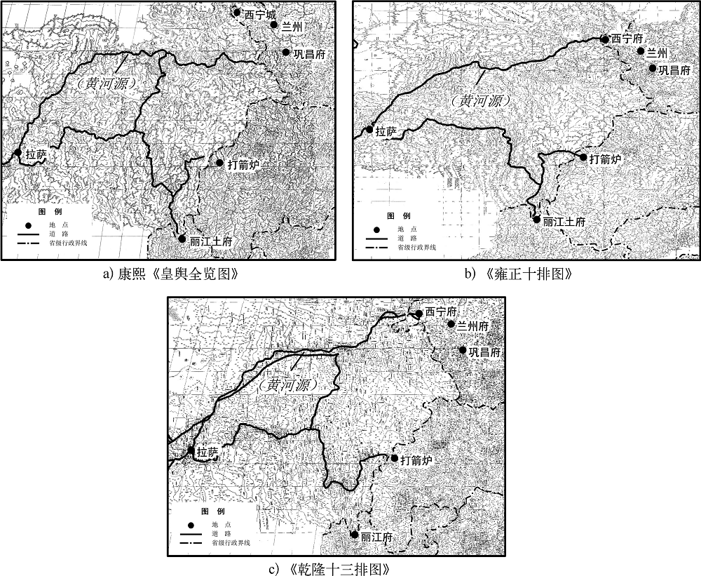
Against the background of modernization, the distribution pattern of roads in Qinghai changed significantly from the beginning of Qing Dynasty to the founding of People's Republic of China. The Xining-Lhasa road was the main line of the traffic network of Qinghai. The changes of the distribution pattern in modern times epitomize the road network distribution patterns of those in the history. Based on a set of old maps from 1935 in the National Library of China, the changing process of the distribution pattern of Xining-Lhasa road in Qinghai were restored. Three driving forces led to road network changes in modern Qinghai: the abolition of the postal system, which led to the collapse of the official road system in last Qing Dynasty, the new transportation system brought by new vehicles, and the developing activities in the period of Republic of China in Qinghai. The changes of the distribution pattern of Xining-Lhasa Road showed the road network pattern in ecologically vulnerable area was prone to the influences from ever changing human factors in the historical period. The restoration of modern roads based on richly surveyed map data was a preliminary work towards accurate restoration of ancient roads.
After the port opening of Shanghai city, social condition experienced great changes. A founding was that the main worshipers of Hong Temple became the prostitute group. The main reasons of such transformation were the prosperity of prostitution thereby and the policy change for sacrificial ceremonies. Newspapers and modern novels accelerated the transformation of traditional folk beliefs in modern Shanghai as well.

Determining the drawing time of traditional maps is an important and fundamental task. Based on the “approaching from both termini” method, and literature and archive review, this paper offers a revisit on the drawing time of two Hongbing (Hong army) military maps of Canton during the Taiping Rebellion, which are now held in the National Archive, U.K. It cannot be clearly proved if the first map (F.O.931/1079) drew on July 18, 1854, whereas the drawing time of second map (F.O.931/1892) can be determined on November 1-2 of the same year, from the period of October 21-26.
