International boundary demarcation is a trouble-causing problem between countries. Before the middle Qing Dynasty, Vietnam was regarded as a vassal state of the Qing empire, thus the boundary demarcation between two governments had not been conducted, and the southwest boundary of the Qing empire was not clearly defined. After the Sino-French war (1883—1885), the Qing and French governments concluded on the Ten Treaties Between Qing and French Government on Vietnam, which ended the vassal relationship between Vietnam and the Qing, thus giving rise to the discussion over the related demarcation issues. In the 11th year of the Guangxu Reign (1885), the Qing government sent Deng Chengxiu to negotiate with French officials on demarcation issues. After long lasting seesaw debates, the two governments finally signed the boundary treaty and drew the boundary maps. The treaty, boundary maps and related files signed by Deng Chengxiu and French officials collected in the Taipei Palace Museum are important materials for the recovery of the boundary negotiations.
Negotiations over the demarcation of the Yunnan-Burma border in the late Qing Dynasty was an important stage of China-Burma border changes in modern times. With the help of diplomatic archives, treaties and maps, this paper makes a detailed restoration of the process of delimitation of the Yunnan-Burma border in the Sino-British negotiations. The signing of Convention Giving Effect to Article Ⅲ of the Convention Relative to Burma and Thibet between China and Great Britain and Agreement Modifying the Burma-China Frontier and Trade Convention between China and Great Britain during the reign of Guangxu basically delineated the middle section of Yunnan-Burma border. The contradiction in the geographical cognition of the “watershed” between China and Britain had an important impact on the negotiation of the undefined boundary in the north of Jiangao Mountain. As a result, China had actually lost the territorial sovereignty of Xiaojiang River Basin north of the Jiangao Mountain and west of Balada-Gaolianggong Mountains. In the southern section of the undefined boundary, China and Britain have many disagreements over the basis of the boundary survey, and it was difficult to reach a consensus. The results of the Sino-British negotiations over the Yunnan-Burma border in the late Qing Dynasty basically shaped the course of the Sino-Myanmar border, and had an important impact on the border negotiations and final delineation between China and Myanmar in the Republic of China period and the 1960s.
In the Former Qin Dynasty (AD 351-394), the Wudu popularized by the Di people in Guanzhong refers to the Lodged Wudu. The establishment of Lodged Wudu began in the Wei Dynasty (AD 220-265). In order to fight for Longyou against Shu Han (AD 221-263), Cao Wei moved the Di people of Wudu to Guanzhong from Longyou, and set up Wudu Commandery in Xiaohuaili and then Meiyang. Jiang Tong’s Xirong Lun (AD 299) reflects that there was no Wudu Commandery in Guanzhong in the Western Jin Dynasty. The Liu tribe of Tuge and the Shi tribe of Jie ruled Guanzhong successively in the Sixteen Kingdoms. They moved a large number of Di and Qiang people to the Guandong area, so there was no condition to establish Wudu in Guanzhong. After Fu Jian established the regime in Guanzhong, he set up Wudu Commandery near Baoji, which was the embodiment of his Di people oriented policy. In the Northern Wei Dynasty, the Lodged Wudu Commandery was set and its territory expanded then before, which marked the localization of the Di people in Guanzhong. It was also a strategy of Taiwu emperor to divide the Di people in the southern area of Guanzhong when he suppressed the rebellion of Gai Wu (AD 445-446). In the Western Wei and Northern Zhou dynasties, the administrative divisions were overused, which cut off the number of counties in the Wudu Commandery. In the Kaihuang period (AD 581-600) of Sui Dynasty, the Lodged Wudu disappeared due to the policies.
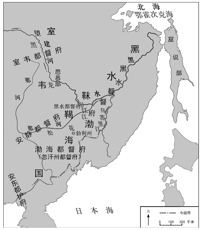
During the period of Kaiyuan’s reign in Tang Dynasty, Boli Prefecture, Heishui Army Arca, and Heishui Genaral Government were consecutively set up on the northern border, where were the later Bohai Kingdom and the district of Heishui-mohe. Using documents and archeological materials, combing with related studies of Boli Prefecture (Bozhou), Heishui-mohe Roadway, Bohai Genaral Government, Anjing Genaral Government, and Simu Tribe of Heishui-mohe, the Jiang’an ancient city of presentd-day Luobei County should be the seat of Heishui General Government in history. The inference also considered the historical background of the military confrontation between the Bohai Kingdom and Heishui-mohe, which caused Heishui-mohe to move northward from the middle and lower reaches of the Mudanjiang River. As a regional strategic center and a geographically significant military and political town, Heishui General Government guarded the north front of the Shangjing (Upper Capital) of Bohai and ran through Heishui-mohe along the line of traffic tunnels; at the same time, it was in accordance with the relative positional relationship between the Bohai Genaral Government, Anjing Genaral Government’s jurisdiction and Simu Tribe of Heishui-mohe. These also proved the Jiangan ancient city being seat of the Heishui Genaral Government set up during the Kaiyuan period of Tang Dynasty.
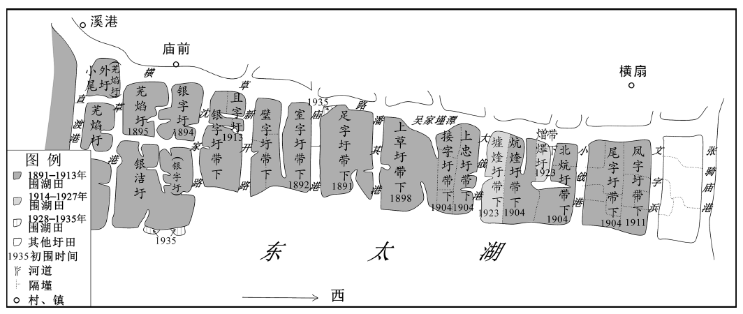
The East Taihu Lake is the main drainage region of the Taihu Lake and an environment sensitive region. After 1890s, immigrants from Henan Province moved into Wujiang County, and they started reclamation in the East Taihu Lake area. From then to the breaking of the Anti-Japanese War, related management policy went through three stages, namely, immigrant recruitment and lift of the ban in the middle and late period of the Guangxu Reign, prohibition of new private ownership and reclamation in 1914, and limited reclamation in 1925. The core concerns of these changing policies seemed to be following a progressive process from focusing on financial needs to water conservancy, and then to a well-balanced development. However, after 1914, due to the financial needs and the fact that the lake conservancy fund had to rely on the sale of marsh land ownership, the authorities not only failed to restrict and guide reclamation activities, but also stimulated its disorderly development by setting up the bureau selling marsh lands ownership with a reduced price, which increasingly deteriorated the water conservancy situations. After the large-scale illegal reclamation in 1935, the authorities had to destroy the dikes of the marsh lands reclaimed privately in order to avoid the extreme consequences and make a rehabilitation plan. All in all, in the process of modern transformation, although technologies and concepts of governance were advanced, they failed to play an effective role in environment governance. The financial capacity was a critical factor affecting the implementation of such policies.
The demarcation of Shaanxi and Suiyuan was an important political event in the adjustments of northwestern provincial boundaries in the early years of the Republic of China. In the course of the whole incident, from the central government and local governments at different levels in Shaanxi and Suiyuan, down to the Ikechao League princes and the local gentry in the disputed areas, the stake-holders made varying appeals from such as the perspectives of national decrees, border security, economic interests in the disputed areas, and decision-making power in grassroots social affairs, to to ask for their own interests. On the border of Mongolia and Shaanxi, the gentry owned the land in the disputed area through the land subscription in the end of Qing Dynasty. The core issue of the demarcation dispute is whether these ownership was still recognized in a new dynasty. In the process of disputes, which lasted for nearly eight years, the central government and local governments, local governments and local governments (both Shaanxi and Suiyuan), local forces and two levels of government competed for their own interests. In the end, the central government gave way to the fait accompli of the Shaanxi side, so the immigrants would not retreat. The local governments and gentry along the border in northern Shaanxi used their prestige and appealed to publicize and guide the people in the disputed area, formed a community of interests, and maintained the “legitimateness” of the right to speak in local social affairs.
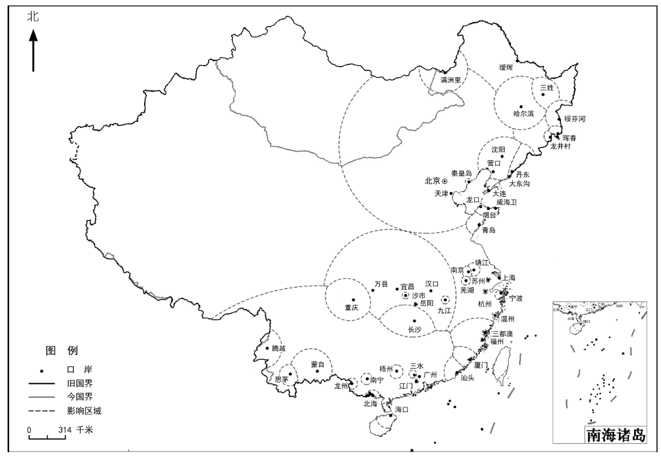
For the most important economic phenomenon in modern Chinese history, the treaty ports system, we can use the research methods of contemporary economic geography, GIS, economics, and so on, to investigate the pattern of modern China’s economic geography and regional economic differences through the investigation of historical data. More than 100 treaty ports in modern China have gradually formed a geographical pattern of opening up to the outside world from the coastal, riverside to border areas, which has provided conditions for modernization, promoted the spatial expansion of modern capitalist mode of production, and reconstructed China’s economic regions. In this paper, first of all, through the discussion of the geographical spatial distribution of the transit duty trade in the treaty-ports system, we preliminarily determine the influence areas of some larger treaty ports; then, with the support of quantification and GIS methods, especially the spatial interactive models, economic regional changes under the influence of modern Chinese trading ports are calculated. Based on this result, the treaty ports system can be regarded as the representative and systematic research object of regional economic modernization, which directly affects the economic geographical pattern of contemporary China, and provides a historical and practical reference for the current economic geographical division of China.
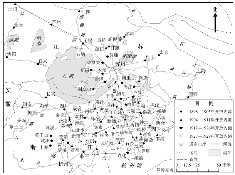
After the Inland Waters Steam Navigation Rules was promulgated by the Qing government in 1898, the inland shipping along the Yangtze River underwent a sudden growth. By 1929, there were more than 418 inland harbors opening to steamship in Yangtze river basin. In terms of distribution, the inner harbors open to steam ships in the Yangtze River basin are spatially concentrated in the lower reaches, less in the middle reaches, and very rare in the upper reaches. In terms of temporal changes, the inland harbors opening to steamship spreaded from lower reaches to upper reaches, and from trunk stream to tributaries. The trend of time and space changes of inner harbor reflects the development of the modern shipping industry in the Yangtze river basin.
Submerged city caused by the drastic changes of hydrological environment is an extreme type of disastrous events. But mirages of the submerged cities recall the memory of this kind of disaster in the form of auspicious illusions. The confluence region of the Yellow River, the Huaihe River and the Grand Canal is well known for its numerous lakes and small rivers, and the river works were frequently rebuilt. It was the core region of the hydraulic conservancy facilities for the clarification of the Yellow River and the water supply for the canal transportation during Ming and Qing Dynasty. In the Qing Dynasty, there was no more need to take the protection of the Mausoleum of Ming Dynasty into consideration in river management. Therefore, the drastic changes of lake environment caused the submersion of the Hongze Town and the Sizhou City, which had profound impacts on the local environment and society. The records of mirages in history are mostly found in the Qing Dynasty when the lake area expanded rapidly. The mirages occurred on Hongze Lake and Gaobao Lakes, and they were mostly associated with the recent or most influential event of submerging city. Although the submerged cities reappearing through the mirages were not credible, it proved that disasters had a lasting effect on people’s memory. It is also a reminder that history needs to be remembered and the disasters should not be forgotten.
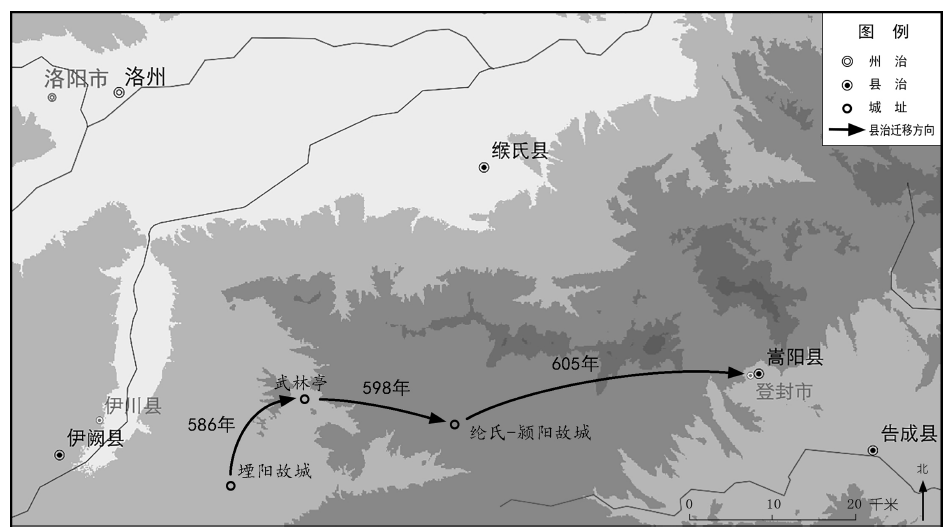
This paper discusses three flaws in General History of Chinese Administrative Regions—The Sui Dynasty Volume. Yanyang county in Luozhou relocated its government in 598 and 605. The relations between Neimou county, Putian county and Jiacheng county in Zhengzhou is complicated because of the relocations of their government seats. The merger of Wenxiang conuty and Hucheng County in Shaanzhou in 596 was also accompanied by a government seat relocation.