
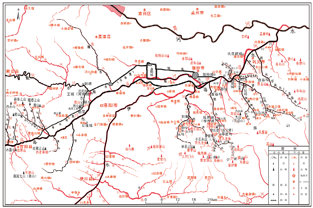
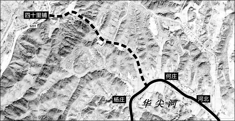
Notes on the Book of Rivers, one of the masterpieces that focuses on describing rivers and records geographical elements in ancient China, is crucial for researching ancient rivers and changes in administrative divisions. Earlier studies on the Notes on the Book of Rivers mostly concentrated on the dissemination of its various versions or on the history of Li Xue, i.e., the study on the classics and its author Li Daoyuan. However, an intensive geographical examination on the text of Li’s notes per se is missing. On the basis of previous researches of related scholars, Luo River, described in the 15th volume of Notes on the Book of Rivers, is selected and analyzed in conjunction with historical documents and archaeological sources in this paper. Hopefully this paper will serve as a useful trial for the study on Li’s notes. Methodologically, it applies texts collation, historical source tracing, reconstruction of the river courses and administrative divisions, and so on. A reconstructed map with ancient-modern place names and a form with ancient-modern river names are also made to demonstrate the results of this study, which will be of convenience for researchers of the Notes on the Book of Rivers. This paper is divided into two parts. The first part has already been published. The second part covers the region from the San Pass to the junction of Luo river and the Yellow River.
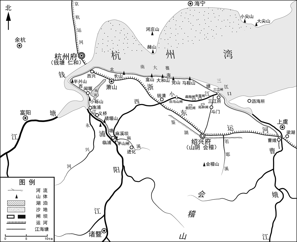
The diversion of Puyang River was key to the development of Xiao-Shao plain in eastern Zhejiang. The archaeological data of the lower Puyang River and the map of Guang Yu Tu (广舆图), which was made in the Jiajing period of Ming Dynasty (1522—1566), demonstrate the basic eastward flow of the Puyang river before its diversion in the middle of Ming Dynasty. The diversion led to the transformation of water affairs in Xiao-Shao plain, re-orienting from the interior of the plain to its edge, and the content of water affairs also changed from “irrigation works” to “flood containment”. The internal reserveoir-centered conservancy system turned to the river wall, sluice, dam and other water conservancy projects so as to resist the invasion of the external rivers and the sea. This transformation also made the rivers and lakes in the Xiao-Shao plain inter-connected into a complete water conservancy system. The establishment and maintenance of the main projects such as Sanjiang Sluice, West River Wall and Maxi Dam brought the three counties of Xiaoshan, Shanyin and Kuaiji in the same plain to form the “shan-kuai-xiao” regional community with water conservancy as the core.
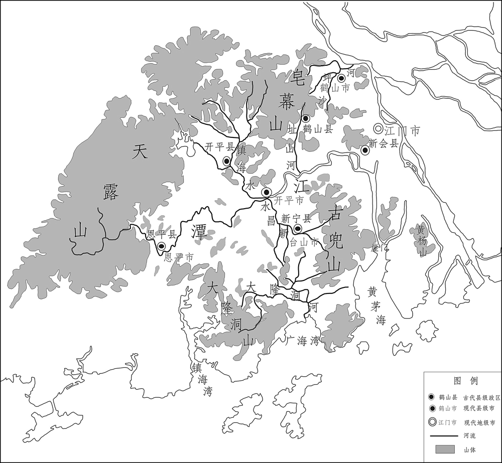
For a time, the Wuyi (five counties) Area was generally located inside the Tanjiang River Basin, a relatively detached geographical unit enclosed by mountains and rivers, when its borders went far beyond the limit of the basin intentionally. Till the Ming dynasty, in order to deal with the local political crisis and civil revolts, the government adjusted the administrative division of the area. Four counties were added or reset, namely Enping, Xinning, Kaiping and Heshan. New borders of these counties were basically in line with the range of Tanjiang River Basin. It was a realization of a geographical unit to affect the forming of administrative borders. In Yongzheng and Qianlong period of Qing Dynasty (1678—1796), the administrative division of this area was roughly accomplished. Xinhui county has become the core county. Along with other four counties in the basin, the Wuyi Area was firstly integrated into a prefecture-level region. The political-geographical changes of Tanjiang River Basin indicated that the geographical environment and local politics played an important role in the forming of political-geographical structure.
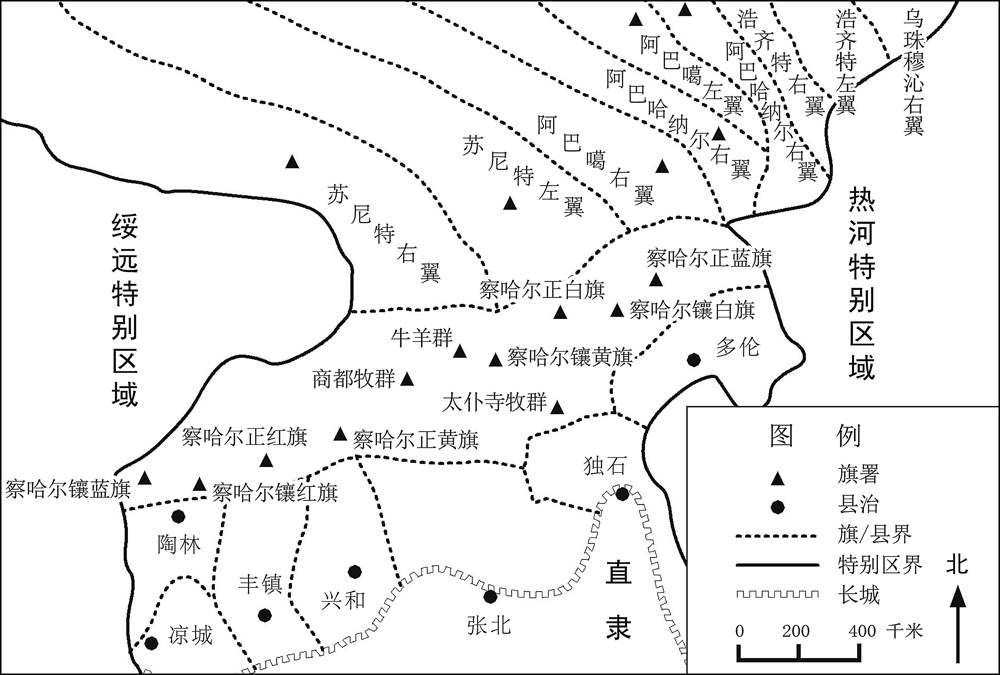
Special Administrative Region was one type of high administrative district, which was established in the Inner Mongolia area in early years of the Republic of China. Due to the borderland crisis, local political and economic situations became important reasons for the special administrative distract establishment. In consideration of vast Mongolian banner area and narrow county area, the central government put Special Administrative Regions into forces instead of provinces. Because of local governors scrambling counties for increasing fiscal revenue, the administrative regions were prone to intense disputes, especially in Chahar area. And in the borderland, ethnic group, military strategy and distance became critical factors in the adjustment of counties.
According to incomplete statistics, there are about 269 city construction inscriptions in Northwest China of the Ming and Qing dynasties. Among them, 32 original stelae still exist in the world, which are valuable first-hand materials for studying the history of cities. The city construction inscriptions of Gansu, Ningxia and Qinghai provinces are most distinctive among this type of inscriptions of the Ming dynasty, which retain a large number of Weisuo (military garrison units) and fortress building inscriptions. The state and county inscriptions mostly have several periods of successive records of city expansion, which are the overall narration of the expansion of city walls. Among all the contents of inscriptions, the state and county related are the most numerous, and the number of Weisuo and fortresses account for a certain proportion. Some other cities, such as post towns, fortress towns, are also preserved, even though the cases are very rare. As the first-hand materials, these inscriptions contain details of the process of city building, the time spent on the project, the amount of silver spent, and the number of donors, etc. These inscriptions are of great historical value for textual research on ancient city-building process, system restoration, social classes, and the expansion of urban functions and forms.
The bamboo-strip manuscripts collected by Peking University has recorded a distance by land and water from Dengpanzhu (邓攀渚) to Luyang (鲁阳) in Qin Dynasty. By comparing the field distance using satellite remote-sensing maps, this paper reconstructs the layout of the traffic nodes along the line, such as settlements, warehouses and ferries. On this basis, further textual research on the track was carried as recorded in the bamboo slips. Finally, the transportation position of Nanyang County in the Qin Dynasty during this period can be re-examined.
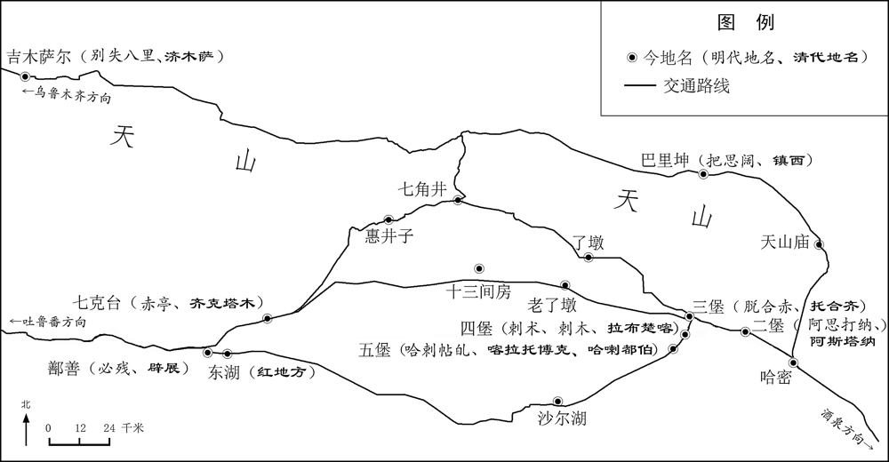
Based on the study of Map of Mongolian Landscape and other documents, this article restores and verifies the “Shaerhu Road”. This road starts from Shaerhu (Shaer Lake) in the southwest of Hami, then turns northwest to Shanshan, finally reaches Turpan, which is different from either Heifengchuan Road in the Ming Dynasty or Xiaonan Road in the Qing Dynasty. The terrain along the road is flat, with spring water and vegetation. It was an important section of the Silk Road in the Ming Dynasty, and continue to be used until the Qing Dynasty. It was widely used in the political and military confrontation between Ming and Turpan, Qing and Junggar in Hami, but was deserted due to the drying spring lake and hot climate.
After the colonial rule of Dutch in Taiwan, the West’s concern for Taiwan has not been ended. On the contrary, there has always been a “Formosa complex”. In 1704, the publication of An Historical and Geographical Description of Formosa written by Psalmanazar, while satisfying the readers’ psychology, was also linked to serious religious and political issues, which led to Propriety Debates. Whether the author was a Taiwanese or not is always been confusing, the analysis of the differences between the different parties about this issue was not only reveals the spread of Taiwan’s knowledge in Europe in the early 18th century, but also the different attitudes of diverse countries to knowledge in different religious beliefs.
Novus Atlas Sinensis, the first printed provincial atlas of China in Europe, was published in Amsterdam in 1655. The Atlas had a great influence on European knowledge of China at that time. The maps and geographical descriptions were drawn and compiled by the Jesuit Martino Martini, mainly based on Guang Yu Ji, a Chinese geographical book published in late Ming Dynasty, which Martini brought back to Europe. By close reading the notes appended by Martini himself onto the “working edition” of Guang Yu Ji now held in the Vatican Apostolic Library, with the help of logical reasoning, the author tries to reconstruct the method and process through which he reckoned the coordinates in the provincial maps of the working edition. The author finds out that Martini completed reckoned the coordinates of more than 1 700 settlements based on only few measured or pre-set values of control points. This was the pivotal step of Martini’s map-making technique. Although the method was inaccurate in modern eyes, by applying it in transforming Chinese provincial maps and fit them into Western standards, Martini successfully produced an atlas which met the requirments of the European mapping industry.
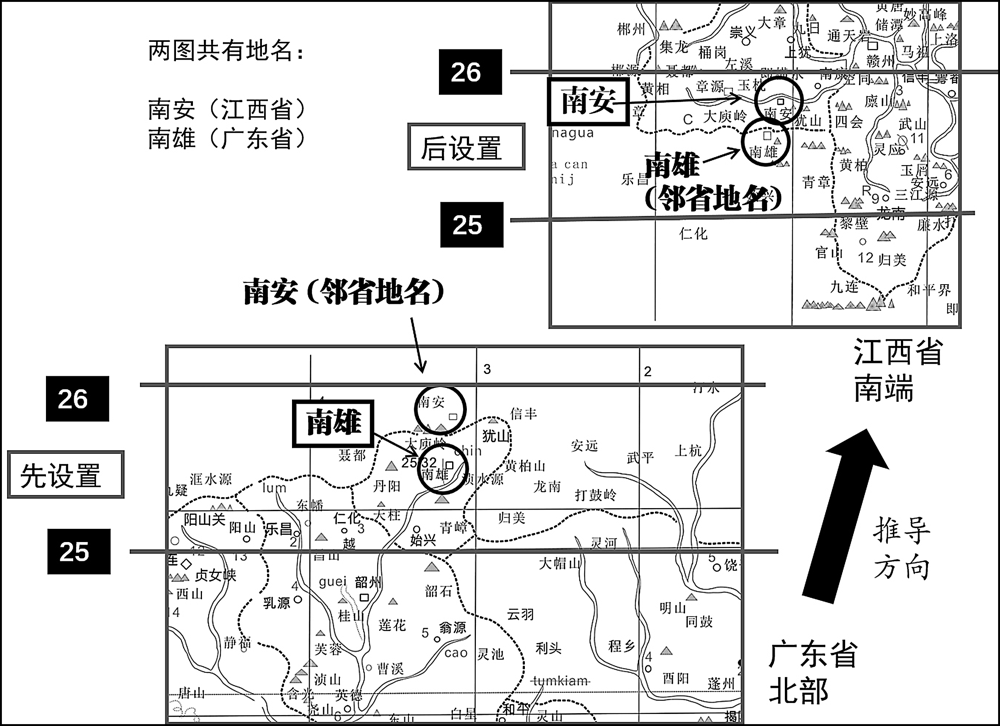
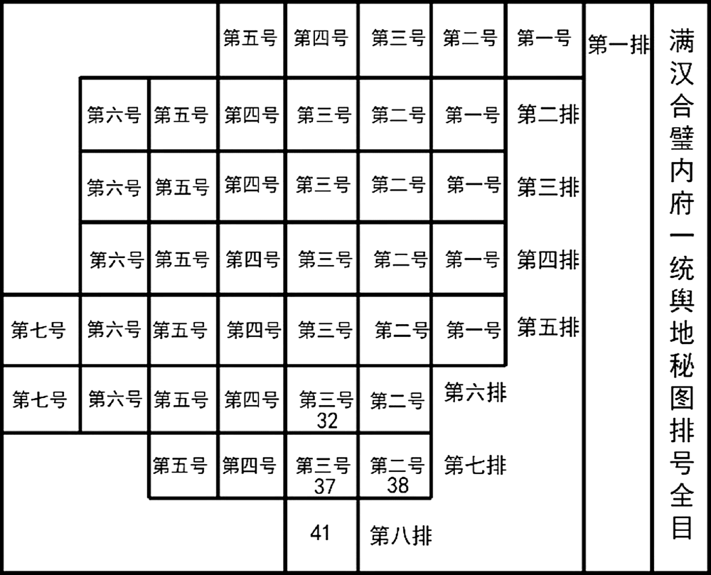
Huangyu Quanlan Tu in Kangxi Reign (an overview map of imperial territories in Kangxi Reign) is an official surveyed map with coordinates accomplished in early Qing dynasty, which deeply affected the drawing of maps until early Republic of China. Digitizing the map contributes to the historical geographic data collection of this time section, and then to ascertain the absolute positions of locations on the map, is in favor of the research on natural and human element changes. Taking Guangdong Area as an example, with different georeferencing methods and historical literature, compare Shisanpai Tu in Qianlong Reign (a map with thirteen rows in Qianlong Reign) with Huangyu Quanlan Tu for the inheritance and development of this area. There is also a comparation of changes between Guangdong and Guangxi Area. The study shows that Shisanpai Tu is based on the Huangyu Quanlan Tu. The coordinate system of two maps should be the same, but there is offset. The difference may be relative with the registration method. The contents of two maps changed as well, which reflects the degree of development of the two regions in early Qing Dynasty.
Dongguan Jun (东官郡) was set up at the sixth year of Xianhe in the Eastern Jin Dynasty (331), the name of which is likely derived from the local salt office. Because of the homonym pair of “官” and “莞”, “东官” or “东莞” was used interchangeably in the literature. In Song Dynasty of the Southern Dynasties, there should have been a unified check which preferred the use of “东官”, such as in the book of annals of prefectures, which is quite different from the materials of biography from the same period. The whole Eastern Jin and the Southern Dynasties period “东官” was never changed into “东莞”. In the second year of Zhide (757) in Tang Dynasty, Bao’an was renamed as Dongguan, which characters are “东莞” that was confused before.