The unearthed documents contain many prefectures and counties in sixteen states period that have been lost in the handed down literatures. They are to be found among the records of local officials and titles of nobility, and are helpful for the study of the evolution and changes of the establishment of administrative regions in different countries at that time. This is a supplementary research for A General History of China's Administrative Divisions, the Sixteen States in the Northern Dynasty. Using these documents, and other partial handed down materials, 68 administrative divisions from 11 regimes have been identified, including the later Zhao, former Liang, former Yan, former Qin, later Yan, later Qin, western Qin, later Liang, western Liang and northern Liang. The 68 divisions include 4 prefectures, 1 town (zhen), 18 counties (jun), 2 towns (hujun) and 43 counties (xian). This study also provides information on supplement questions such as the movement of seat of Pingzhou in the later stage of former Yan, the duration of existence of Lelang County, the hierarchical position of Wushi County and Chongquan County, the nature of Youzhou County in the later Qin and Wuwei County in the western Qin, the hierarchical position of Jinzei County in the later Liang, the true and false of Yong'an County and the hierarchical position of Wansui County in the Northern Liang, etc.
The Yanran Protectorate(燕然都护府), as well as Yunzhong(云中) and Dingxiang(定襄) prefectural governnorates were the main northern border governing institutions of the Tang Dynasty. A study on them also affords an important window into exploring the political evolution in the north in the early Tang Dynasty. In the first year of Yonghui(永徽), the Regime of Chebi was crashed and the whole Mongolian Plateau was unified by the Tang Dynasty. According to the principle of “separation by moraine and partition” which had always been adhered by the Tang Dynasty, there have been put forward three hypothesis, namely “three-protectorate theory”, “two-protectorate theories” and “one-protectorate theory” regarding the governance pattern of the northern territory. In fact, the type of Jimi prefectures on the Mongolian grassland had indeed proliferated after the unification, but there was only one protectorate, which was responsible for strengthening the contact with the northern part of the plateau. The rest of the southern tribes under Jimi prefectures was under the supervision and leadership of the two governors of Yunzhong and Dingxiang.
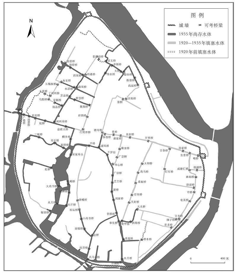
At the turn of the Twentieth century, Western municipal concepts and theories were gradually introduced into China along with the examples set by treaty port cities. Some traditional cities formed in the dynastic time also began to carry out modern municipal constructions. In this study, we take Ningbo old city as a typical case and focus on three ways of road improvements in the 1920s and 1930s: the demolition of the city wall, the filling of rivers and the removal of residential buildings. Based on earlier studies, we use large-scale old maps and local gazettes to restore and analyze the river channels and road networks. It shows that for the traditional cities in China, due to the lack of motivation and capital, even if the urban administrative districts had been set up, it might not be able to promote the conditions. On the contrary, it caused many social problems especially during the expropriation of construction land.
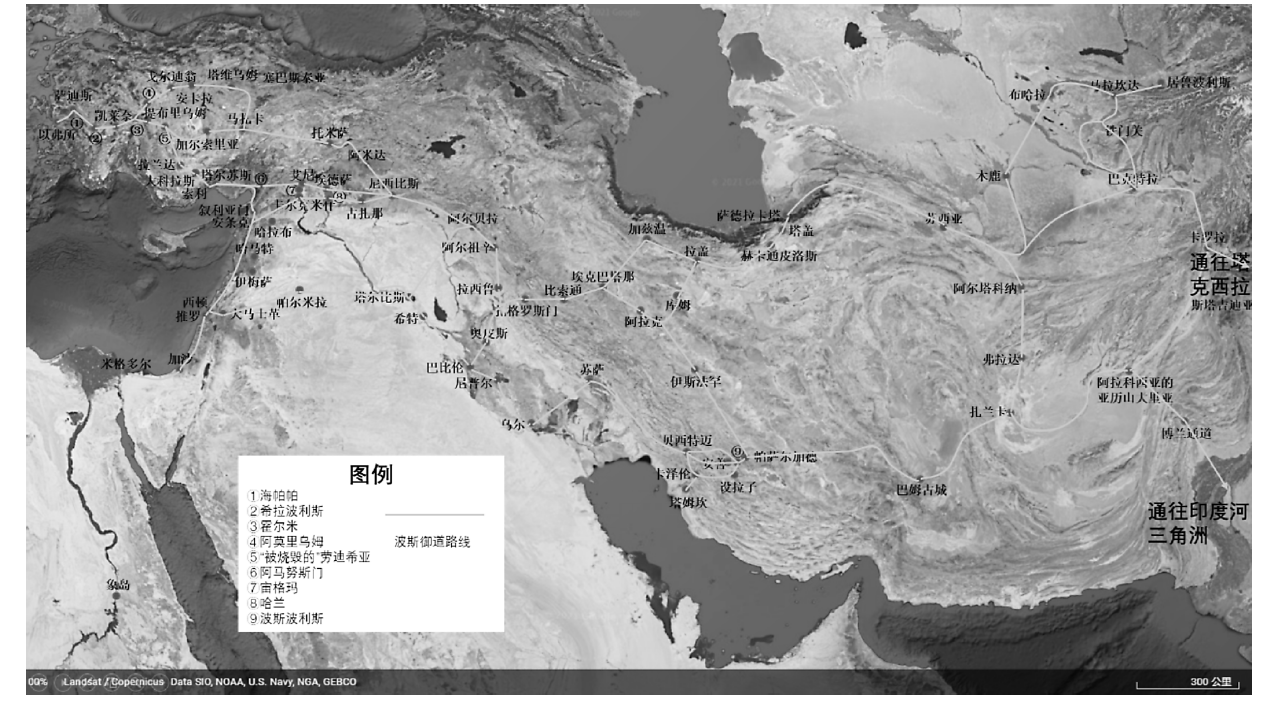
The Royal Road System was a road network of the Persian Empire, and routes of the Royal Road System have long been disputed among scholars. The records in Herodotus's History and Persepolis Administrative Archives reflect the general characteristics of the Royal Road which are also the criteria for identifying them from ancient roads. Although multidisciplinary research methods have provided assistances to the reconstruction of routes of the Royal Road System, they also caused many controversies. In general, routes of the Royal Road System in Anatolia, Mesopotamia, Syria and Armenia are relatively accurate. There is no way to infer routes of the Royal Road System in Egypt or Arabia. Routes of the Royal Road System in eastern satrapies are based on classical texts. However, the Royal Roads were not the general term for ancient roads in Persian Empire, and the diachronic changes of ancient roads are still very significant. With the help of the interpretation of cuneiform characters, archaeological excavations and scientific historical geography, the study of the Royal Road System may will overcome its dependence on classical texts research.
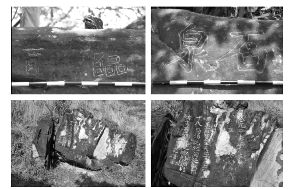
Goulan Shan was one of the most important landmarks on the route between China and Java in the Yuan-Ming Period. Scholars usually believe that Goulan Shan is located to the southwest of Kalimantan Island and known as Gelam Island now. However, newly discovered Chinese inscriptions in Indonesia indicate that Serutu Island is where Goulan Shan was located. Through comparative analysis of geographic remote sensing data and traditional documents, the records on Goulan Shan are roughly consistent with the geographical environment of Serutu Island and its surrounding areas, but are quite different from that of Gelam Island. The invasion by the Yuan Dynasty into Java indirectly contributed to the prosperity of Serutu Island in late Yuan and early Ming, while the policy of maritime embargo in Ming Dynasty and the depletion of animal resources may be the main reasons for the decline of the island's status after the mid-Ming.
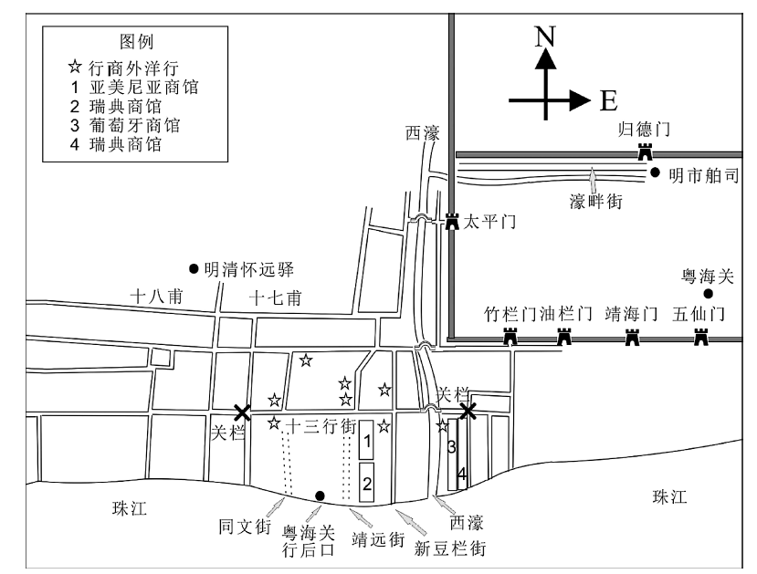
The Huaiyuan Posthouse of Canton was located in Xianzibu, Sai-kwan from the Ming to the early Qing Dynasties, which was the place where the Kwangtung Shi-Po-Si(广东市舶司) received the tribute ships and foreign envoys onboard those ships. It also functioned as the site for China-foreign tributary trade. With establishment of the Hoppo during the Kangxi reign, the Thirteen Hongs (factories) were assigned with the task of undertaking foreign trade. After many efforts, foreign tradesmen were allowed to rent commercial houses and set up factories in the Thirteen-Factory Street to the south of the Huaiyuan Posthouse. The Hongs were was managed by merchants. The Huaiyuan Posthouse was abolished in the late Kangxi emperor. The Thirteen factories basically replaced the functions of the Huaiyuan Posthouse. The essence of this shift from the Huaiyuan Posthouse to the Thirteen Hongs is the declined of the tributary system in Qing Dynasty and the rise of the Canton trade through the Hongs.
The successful promotion of American tobacco in Yunnan during the Anti-Japanese War is a turning point in the history of the development of the tobacco industry in Yunnan. It is the result of the comprehensive action of several factors. Among them, the unprecedented market demand is the driving force of promotion. The key to the success of popularization is the adoption, based on experimental research, of a set of cultivation techniques suitable for the natural environment of Yunnan. Due to the solid foundation laid by this promotion campaign, the advantages of Yunnan's natural environment, which is suitable for tobacco planting, have been highlighted. The interaction between nature and man paved the way for Yunnan province's status as a major tobacco producer.
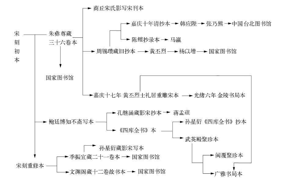
Since the Northern Song Dynasty, Yudi Guangji has been issued in many different versions. In addition to the original version, there were two more re-issued editions from the Southern Song Dynasty. In the Qing Dynasty, many more editions were issued either based on the original version or the re-issued versions. The Qing versions are on the one hand comparatively independent from each other, and on the other hand complementary to each other. To compile the best edition of Yudi Guangji, one has to rely on the original Northern Song Dynasty version, and consult with the other versions.
Collected by the Nanjing Museum, the Atlas of Border Towns mainly depicts fifteen border towns of significance in Ming dynasty. It used to be collected and commented by Yizhai. The atlas is also compiled into Atlas of Ancient Maps in China (Ming Dynasty) and Collection of Ming Dynasty Maps. After been inspected by Zhang Baochai, the atlas gradually draws attention from the academic circle. According to the current research, the atlas was produced during the 32nd to 33rd year of the Wanli's reign of Ming Dynasty, with Luo Hongxian's Enlarged Terrestrial Atlas as its main reference. Its collector, Yizhai, was believed to have lived in Qing Dynasty. However, after examination and verification, it is proved that the atlas was drawn during the 3rd to 4th year of Kangxi's reign of Qing Dynasty. The author of the work, whose surname is Huang, was a Ming loyalist. He mainly referred to Chen Zushou's Atlas of Territories of August Ming. The collector of the work, Yizhai, is Cheng Zhiqing, a seal carver from Suzhou. Bonze Yiling could be inferred as Qu Dajun, a famous scholar who lived in the early Qing Dynasty.
In the era spanning from the late Qing Dynasty to the Republic of China, the Chinese Customs charted and published Chinese maps that amounted to close to one thousand. They constituted most of the maps charted and published contemporarily in China. Many of these maps were superior in quality and accuracy than most traditional maps and were supplemented with detailed texts. Given that Chinese Customs publications are mostly collected in libraries and archives that restrict access, the maps are also generally neglected by researchers. To familiarize researchers with them, this paper provides a detailed introduction to these maps, which covers the time of their charting, the variation in the areas charted, a classification of their types, and the origins and characteristics of these maps.
During the Puppet Qi Dynasty, Mianchi County(渑池) was changed to “沔池” to avoid breaking the taboo of using a character from Emperor Jin Taizu's name, namely Wanyan Min. “渑” is a multi-syllabic character, and when used as the county name it does not involve taboos. The regime of Jin Dynasty does not avoid this word. But to please Jin, the Puppet Qi deem “渑” as a taboo character, and used the nearest homonymous character “沔” as a substitute. After the Jin Dynasty re-ruled Henan, they did not change back the county name, and the Jin never strictly avoid the word “渑”. “沔池” was used as the official name during the Jin Dynasty, and it became alias of the county in later dynasties interchangeable with “渑池”. In the new and old annotated versions of Jin Shi, it should be restored where “沔池” had been mistakenly changed to “渑池”. For other literature, unless there is sufficient evidence that “渑池” was used in the original version, “沔池” should be kept and not changed into “渑池”.
There are seven misrecords under the entries of Nanjing and Henan in the Geographical Records of the Ming History, namely, Haimen of Yangzhou, Jiading of Suzhou, Ningguo, Shenqiu of Kaifeng, Yuzhou of Kaifeng, Xiayi of Guide, Henei of Huaiqing. Through the textual researches, the above errors can be corrected, and the original appearance of local administrative divisions in the Ming Dynasty restored.