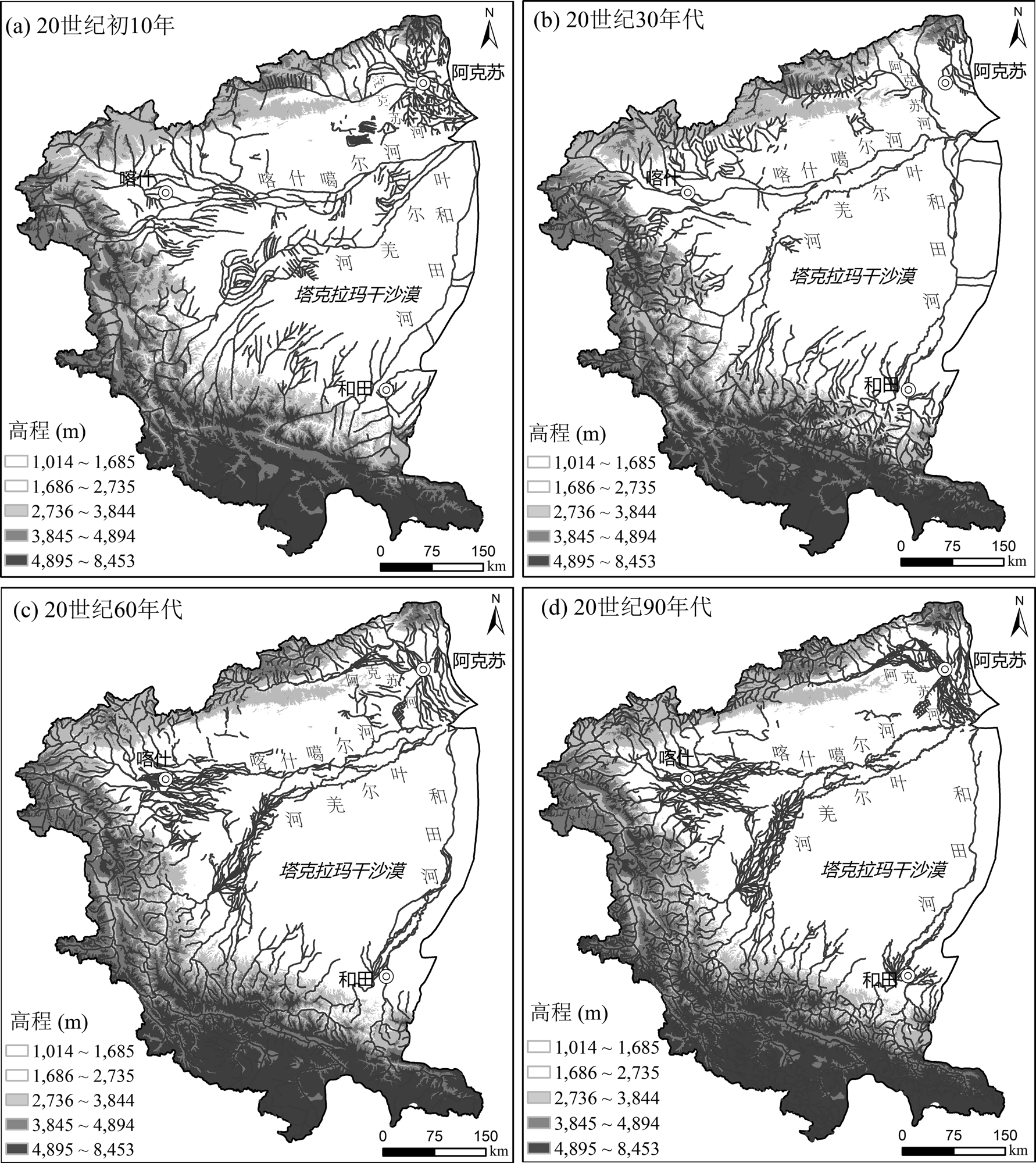
Based on multiple sources of evidence, including historical documents and hydrological data, this study reconstructs the river network patterns in the upper Tarim River region during four representative periods—the early 1900s, the 1930s, the 1960s, and the 1990s—by comprehensively applying quantitative and statistical methods such as spatial autocorrelation analysis, fractal analysis, and river sinuosity. The evolutionary characteristics of river system morphology and their driving mechanisms are then analyzed. The results indicate that river network density in the study area exhibits significant positive spatial autocorrelation across all four periods, with the degree of spatial clustering increasing overall through time. Meanwhile, the overall fractal dimension of the river network shows a continuous upward trend, reflecting a persistent increase in the complexity of the spatial structure of the river system. Within the basin, the fractal dimensions and sinuosity of the Aksu River, the Kashgarer River, and the Yarkand River increase markedly during the mid-to-late twentieth century, whereas changes in the Hotan River are relatively limited. This pattern reflects differentiated responses of river system morphology among sub-basins to human activities. Further analysis incorporating hydrological and sediment conditions, as well as the historical context of irrigation development and agricultural expansion, demonstrates that human irrigation activities have exerted a direct impact on the morphological evolution of the river system since historical times.
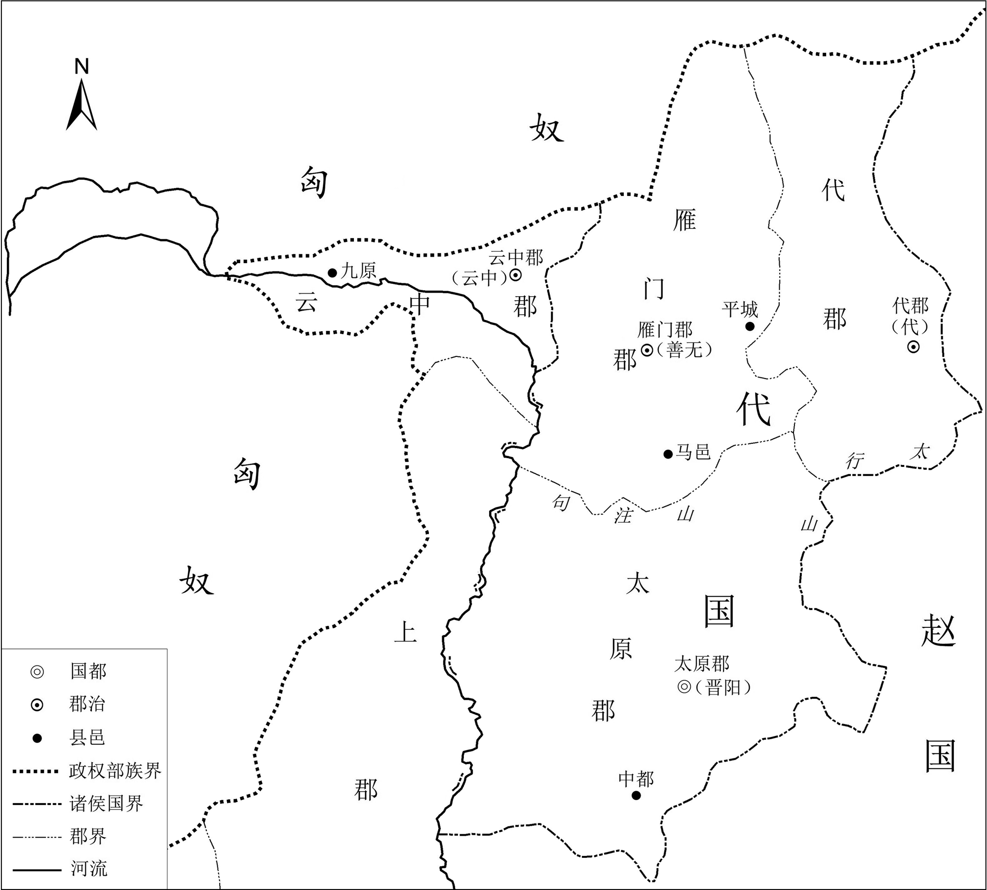
Due to the rise of the Xiongnu, the Dai region in the early Han Dynasty was unable to resist frequent invasions. In response, Emperor Gaozu of Han continually adjusted the enfeoffment arrangements for Dai to address the new challenges. It was not until the 11th year of his reign that Liu Bang detached Yunzhong Commandery from Dai and placed it under direct imperial control, while compensating the King of Dai with Taiyuan Commandery, thereby stabilizing Dai’s governance. The underlying rationale for this administrative adjustment was to reduce the frontier defense burden on the Dai Kingdom, increase resource supply, and establish a strategic depth. However, this also imposed the heavy responsibility of defending Yunzhong on the central court, necessitating preferential policies. The territorial adjustments of the Dai Kingdom in the early Han Dynasty exemplify the spatial strategies adopted by Western Han frontier commanderies and vassal states in dealing with neighboring nomadic peoples, demonstrating a certain degree of typicality.
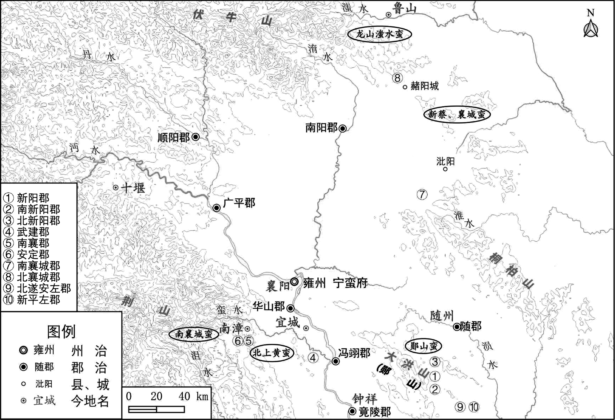
The Ningman Commandery (宁蛮校尉府) originated from the system of the governors of the ‘Intermediate Zone’ concurrently holding the title of Commandants for Suppressing Man (镇蛮护军) during the Eastern Jin Dynasty. Initially, it was merely a title concurrently held by the commander of Yongzhou (雍州). During the Yuanjia (元嘉) period of the Liu Song Dynasty, a large number of ‘Man’ people (蛮人) in Yongzhou submitted to the court, which prompted the Ningman Commandery to perfect its staff organization, appoint Man chiefs as local rulers, and set up ‘districts and counties’ for management. Consequently, it evolved into a military and political institution with independent administrative functions. The Chief of Staff, Military Advisor, and Registrar of the Ningman Commandery were appointed by the central government. Their primary responsibility was to administer the Man people. The residents of the Man districts, under the leadership of the district chief, would fight alongside the imperial armies. Examining the evolution of the Ningman Commandery can further reveal the interactive relationship between the Southern Dynasties and the human groups in the mountainous areas of southern China.
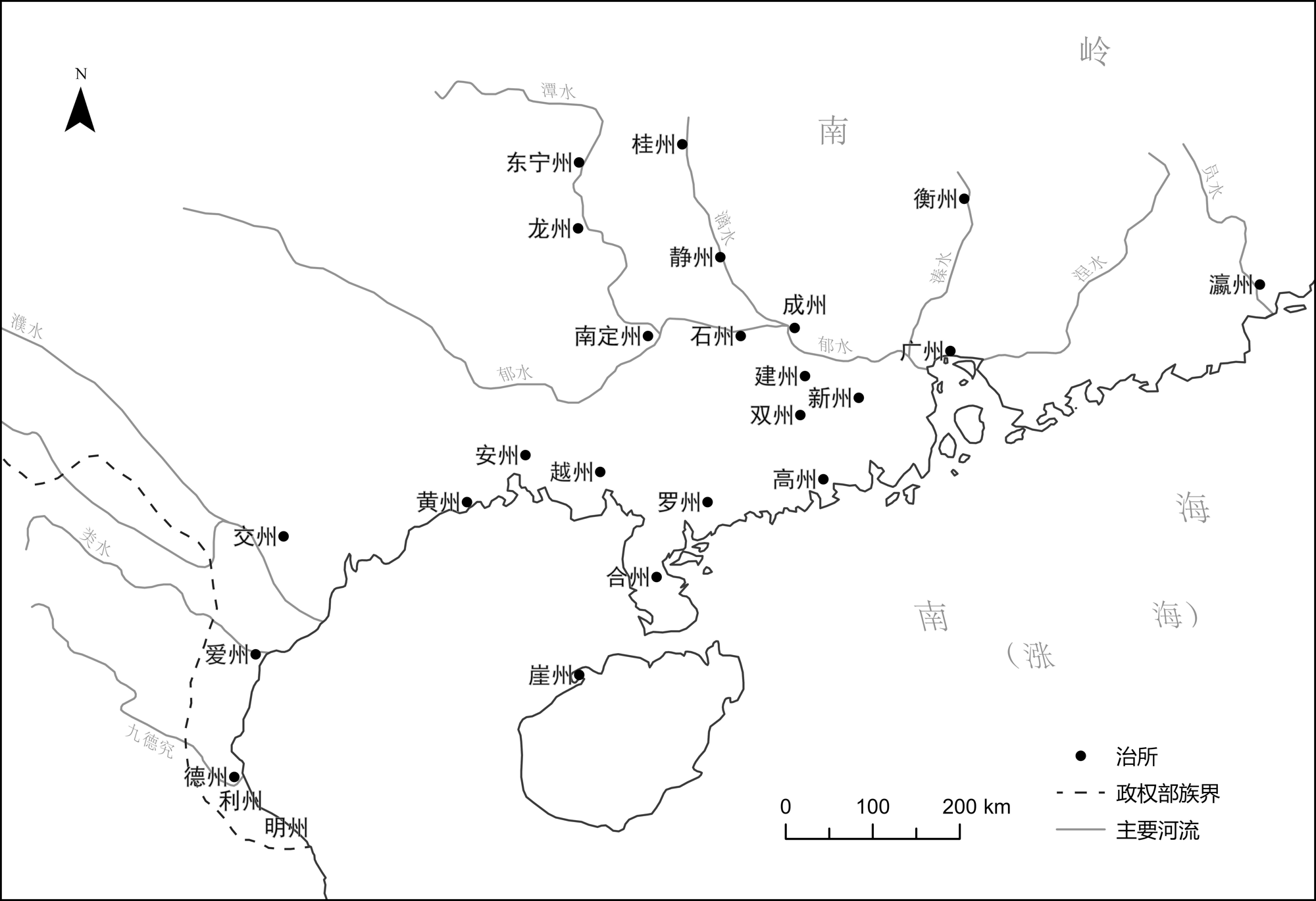
More than 20 new states were established in Lingnan(岭南) Region in the Liang Dynasty. With the addition of a large number of states, the construction of captaincy district(都督区)became more complicated. In the Eastern Jin, Song and Qi Dynasties period, the military and political pattern in which the Guang state- Captaincy district was permanently established and the Jiao state- Captaincy district was occasionally established was maintained in Lingnan. Since the Tianjian period of Liang Dynasty, the Guang state- Captaincy district, the Heng state- Captaincy district, the Nanding state- Captaincy district, the Gui state- Captaincy district and the Ai state- Captaincy district emerged and coexisted one after another in Lingnan, which showed the development trend of a multi-centered military and political pattern. The adjustment of State and Captaincy district of Lingnan in Liang Dynasty, which reflected the reconstruction of the political geography patterns in Lingnan during the process of the imperial-state strengthening regional control and adjusting the relationship between the central government and local regions.
During the Qing Dynasty, the inheritance of existing administrative district names and adherence to traditional naming principles led to numerous instances of duplicate administrative names across various categories as administrative divisions underwent changes. Influenced by factors such as administrative hierarchy, regional connections, types of affairs, and patterns of name duplication, these duplicate names exerted multifaceted impacts on individuals, localities, and national administrative procedure, fostering diverse interactions within society. The Qing court sought to eliminate duplicate county names within provinces through renaming, while adding provincial names to seals of duplicate administrative units to mitigate potential confusion. These measures aimed to maintain administrative stability and reduce costs. However, the combined effect of both approaches paradoxically contributed to the continued growth of duplicate names. This demonstrates the limitations of the court’s ‘limited governance’ model in resolving duplicate administrative names, revealing the complex interplay between place names and the state, society, and institutional frameworks.
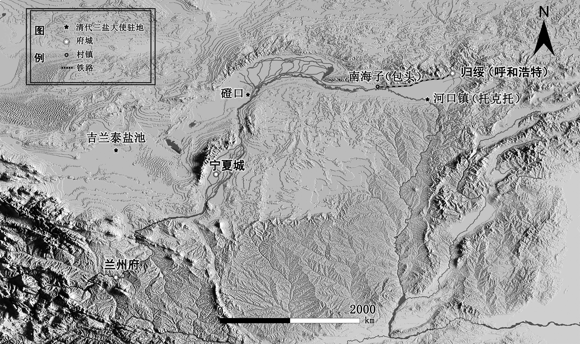
The opening of Tianjin port facilitated the export of livestock products from Northwest China. In the Hetao region(河套地区), the traditional trade route connecting the Mongolian Banner to Shanxi evolved into a wool export route serving nomadic areas in modern times. This shift was marked by the rise of Nanhaizi(南海子)in Baotou as a key trade hub, replacing Hekou Town(河口镇)in Tuoketuo(托克托). Amarket network extending from north to east, interwoven with routes for sheepskin rafts and cowhide rafts as well as camel caravan, connected Inner Mongolia with Gansu, Qinghai, Ningxia, Xinjiang and even northern Shaanxi. This network transformed the traditional Silk Road trade pattern, creating a new economic community centered on the production and export of livestock products. The emergence of this economic community redefined the concept and boundaries of the Northwest region, leading to the establishment of the ‘Six Northwestern Provinces’ as a distinct regional designation during the Republic of China. The conceptualization of the ‘Six Northwestern Provinces’ in the Republic of China was based on regional economic integration, and reflected the reconstruction of northern China’s market network in modern times.
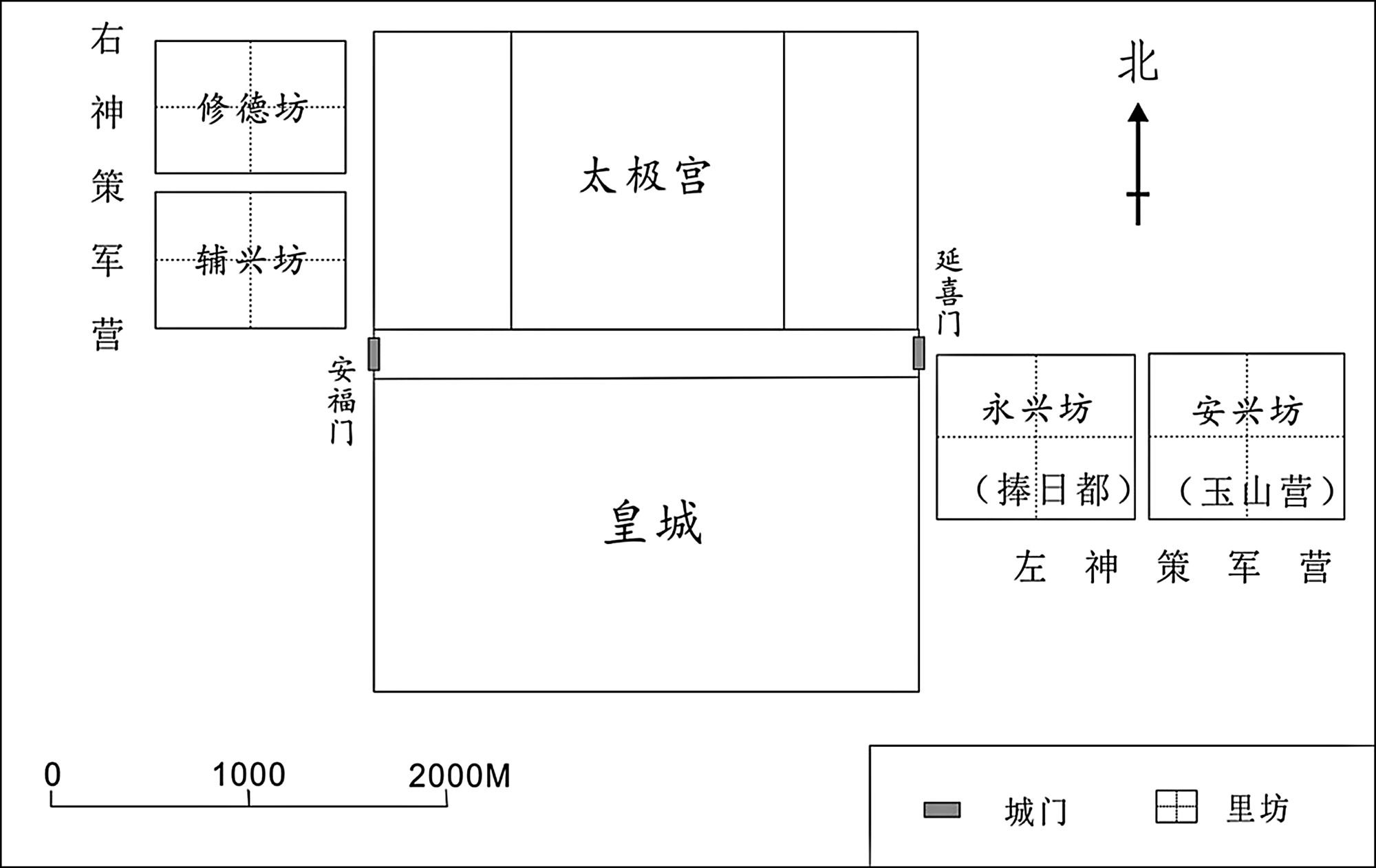
The textual research on the offices’ location related to the ‘inside’ and ‘outside’ of Tang Chong Xiu Nei Shi Sheng Bei (《唐重修内侍省碑》) proves that the restoration project of Chang’an City presided over by the Nei Shi Sheng from the 2nd year of Qianning to the 2nd year of Guanghua (895-899), Its central reference point is not the Daming Palace in the east, but the Taiji Palace in the west. This refurbishment finally presents a relatively regular pattern with Taiji Palace as the center, Chengtianmen-Zhuquemen as the central axis, and related offices wings. This reconstruction pattern is also an objective portrayal of the changes in the political power center in Chang’an City from the Qianning to Guanghua years of Emperor Zhaozong of the Tang Dynasty.
The route of postal delivery from Huiningfu (会宁府) to Sizhou (泗州) was the main north-south traffic line of Jin Dynasty and diplomatic route for envoys between the Song and Jin Dynasties. The development and change on this line were the representation and epitome of traffic system of postal delivery in Jin Dynasty. Based on diplomatic literature of traffic system of postal delivery on this line from envoys of Song Dynasty in different periods. The route of postal delivery from Huiningfu to Sizhou was continuous development and improvement from 1124 to August 1143. From August 1143 to the end of the year, the government of the Jin Dynasty significantly abolished and adjusted posthouses on this route of postal delivery, and changed name of new posthouses from ‘Pu’ (铺) to ‘Guan’ (馆) due to the implementation of the peace treaty between the Song and Jin Dynasties. This reform established postal and courier system in Jin Dynasty. The mature traffic system of postal delivery of Jin Dynasty had two functions of posthouse and postal delivery, and this system was controlled by the Ministry of War. Emperor Jinzhangzong (金章宗) established Jidipu (急递铺) system for the war to the Southern Song Dynasty, and this reform to some extent separate the two functions of original traffic system of postal delivery. But Emperor Jinzhangzong’s reform was cancelled in the Late Jin Dynasty. The traffic system of postal delivery in Jin Dynasty was similar to the Early Tang Dynasty, but was different of separation of the two functions in the Middle and Late Tang, Song and Yuan dynasties.
Jahān-nāma is a Persian geographical work written by Mulammad bin Najīb Bakrān in the early 13th century. The records about China in this work represent the updating and transformation of knowledge of China from the perspective of Muslim scholars. The perception of China in the geography of the Middle East is based on geographical works written in the 9th and 10th centuries. When these works mention China, they mainly reflect the situation during the Tang dynasty and earlier periods. After the 10th century, Muslim scholars gradually incorporated new information about the Khitay regime into their existing knowledge framework, but they still did not abandon records about the Tang Dynasty from the past. In the 13th century, when Jahān-nāma mentioned the situation in China, it not only introduced new records but also discarded outdated information. Moreover, it supplemented and corrected some existing knowledge. However, in later Arabic and Persian historical and geographical works, there is little utilization of the records in Jahān-nāma when it comes to the situation in China. This is because, after the completion of Jahān-nāma, the Mongols began their westward expansion. Through the increasingly frequent exchanges between China and the Middle East under Pax Mongolica, Muslim intellectuals could use more fresh and accurate information about the Jin dynasty and the Yuan dynasty to supplement and update the records of older works like Jahān-nāma.
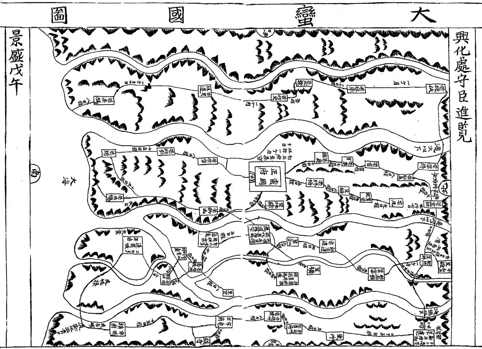
The Đại Man quốc đồ or the Map of the Great Barbarian Kingdom (《大蛮国图》) collected in the atlas of ancient Vietnam namely $\text { Bản đồ Hồng Đúc }$ (《洪德版图》), is a map of Burma drawn by the officials of the Tây SFn Court in the later 18th century. Đại Man quốc đồ was the official designation used by the political elites of northern Vietnam in the late 18th century to refer to the Kongbaung Dynasty of Burma. In response to military challenges from Siam, Burma and Tây SFn sent several missions to each other and tried to establish harmonious diplomatic relations between 1792-1802, and the Đại Man quốc đồ was a historical product of the political interaction between the two countries during this period. Currently, there are three versions of the Đại Man quốc đồ around 1800, namely the lost imperial edition or $\text { ‘ Cựu đồ Cảnh Thịnh’ }$ (景盛旧图, 1798), the $\text { ‘ Tân đồ Cảnh Thịnh’ }$ (景盛新图, 1800), and the untitled edition (1802-1805). As an official map depicting a ‘foreign land’, the Đại Man quốc đồ not only intuitively presents the geographical situation, transportation routes and political situation of Burma from the view of Vietnam, but also reflects the geographical cognition and intelligence collection of the ancient Vietnamese dynasties on the hinterland of the Indochina Peninsula, and concentrated displays the genealogy of geographical knowledge based on the inland perspective of northern Vietnam.
In the first year of Yongchang era of the Emperor Li Dan (689 AD), a large-scale battle occurred between Tang Empire and Tubot in the area of Yin-zhi-jia River (寅识迦河) in order to seize the Western Region. However, in the academic community there are many disputes over the geographical location of the battlefield. According to the phonetics, the word ‘Yin-zhi-jia’, which means slender, is supposed to be a transliteration of the Old Turkic. In the Tang Dynasty, the approximate location of the Yin-zhi-jia river was along the Ying-qi-gai river, which is located south of Yanqi (Qarasheher, 焉耆).
An Investigation of the Two Capitals of the Tang Dynasty is a foundation work to study Chang’an for recent scholars. In recent times, scholars have repeatedly updated it, but the Tang poetry material is still missing. Now, mainly based on the poetry of the Tang Dynasty, we have supplemented the Chang’an section of An Investigation of the Two Capitals of the Tang Dynasty with sixteen entries, thereby compensating for what previous scholars failed to achieve.