Since Shang Dynasty, during which the earliest textural records emerged, capital cities of various dynasties have served as national centers of politics, economy and culture. Evolutions of planning and management of capital cities have been a significant aspect in the historical research, because they can reflect changes in economic and cultural characteristics in a corresponding period. More than ten cities were designated as the capital city of China at some points in the history. To address the representativeness of capital cities, in 1920s, the academia listed Xi’an, Luoyang, Beijing, Nanjing and Kaifeng as Five Ancient Capitals. Hangzhou was added to this list in 1930s, making the list into Six Ancient Capitals. In 1980s, Tan Qixiang proposed to add Anyang (known as Yin or Ye) to the list, which would turn the list into Seven Ancient Capitals. At that time, this proposal triggered intense discussions in the academia. It was eventually approved by the academia and became a consensus among mainstream historians. These three letters, presented here, were written in late 1980s. They were exchange letters addressing the proposal mentioned above between Tan Qixiang and local scholars in Anyang. Through these letters, we could also notice the professional attitude and scientific spirit that scholars in the earlier generation used to carry.
The region where Yellow and Huai Rivers met the Grand Canal became a key location for water regulation because of the opening of Grand Canal in Ming Dynasty. Regulation procedures implemented by the government, aiming to keep the Grand Canal unimpeded to navigation, facilitated the evolution of river system structures and water regimen. In early Ming Dynasty, the configuration of river channels was similar to that in Yuan Dynasty, following a pattern of parallel flows with interchangeable main and tributary channels. As the Grand Canal, Huai River and Yellow River were under regulation, and especially as levees were constructed, channels of Yellow River went through a concentration process. They firstly merged from a regional network pattern into a linear pattern, and then continued converging towards a point at Qingkou. The first stage of this process was the abandonment of the northern branch of Yellow River, while the second stage was lining the Xu-Pi segment of Yellow River up with the upper stream. After flow directions of channels were fixed into the Xu-Pi segment, most levee failure events during the Reign of Jiajing Emperor occurred upstream to Xuzhou, but after the 44th year of Reign of Jiajing Emperor, most of such events occurred downstream to Xuzhou. The channel regulation near where Yellow River and Grand Canal meet started with a broader, fan-shaped target region extended from south to north, and then reduced to the southern half of the fan-shaped region, and then concentrated to a linear belt and eventually to Qingkou. The regulation generally served for maintaining the navigational condition of channels. From a regional channel network to a point, or from a broader region to a smaller region and eventually to a single point, such kind of engineering process marked the characteristic of how Ming Dynasty conducted hydrological regulation projects in the region where Yellow and Huai Rivers met the Grand Canal. This hydrological regulation process that follows the change of water environment accordingly fully reflected the wisdom of ancient people in utilizing the aquatic environment on a large regional scale. It has remarkable ecological characteristics.

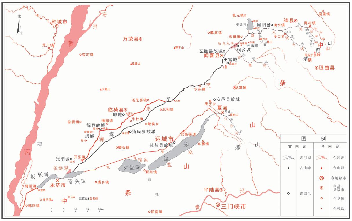
Shui Jing Zhu(Notes to the Book of Rivers) is a well-known classic work from ancient China on geographical features arranged by river channels. It has considerable significance in studies on earlier changes of river channels and administrative divisions. In this paper, we study Commentary on Sushui River, the sixth volume of Shui Jing Zhu. Based on previous studies, we utilize related textural and archaeological evidences to conduct a comprehensive analysis on this volume. Components of our study include the collating on original texts, locating historical sources, and reconstructing the distribution of river channels and settlements. To intuitively visualize results of our study, we also generate a map that compares ancient features with modern ones.
In the second volume of Liye Qinjian (Liye bamboo and wood slips), new records of prefectures and counties in Qin Dynasty were discovered. We summarizes 4 prefectures and 34 counties based on this book, in which Chengfu county was in Huaiyang prefecture and Xincheng county was in Dongting prefecture. Texts on slips reveal the process of how documents were sent from Xianyang, the capital of Qin Dynasty, to Nanyang, Nan and Dongting prefectures in order, and their transmitting routes and methods within counties under Neishi (the vicinity of capital) and prefectures, and within townships under counties. From Liye slips, we can complete the list of all counties administrated by Dongting prefecture. Moreover, we can infer that the prefectural seat of Dongting prefecture was originally in Xinwuling county, and was then moved to Linyuan county during the 29th or 30th year of Emperor Qin Shi Huang’s reign.
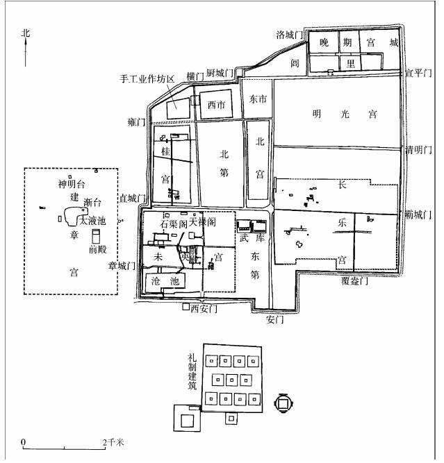
The North Army was the city defense force set up with the construction of Chang’an during the later period of the Emperor Hui’s reign, and was an important armed force in Han Dynasty. In the early stage of Han Dynasty, there were mainly two palaces lying in southern Chang’an and the leader of the palace defense army (Weiwei) was in charge of the palace defense issues. The city defense army could only be stationed in northern Chang’an. Accordingly, the palace defense army was known as the South Army and the city defense army was known as the North Army. Based on Law of the 2nd Year: the Payroll Law discovered on bamboo slips from Zhangjiashan, the chief officer of North Army was Guard General (Wei jiangjun). Secretary of Guard General (Wei jiangjun zhangshi), Chief Assistant (Houcheng), Chief Colonel (Xiaozhang) and lower-ranked civilian officers were also in the administrative system of North Army. At that time, Guard General was the only permanent General in the entire bureaucratic hierarchy of Han Dynasty. After Emperor Wen ascended the throne, Guard General obtained more power by taking command of the South Army in addition to the original North Army. After that, the North Army had been dismissed and reestablished for several times. The position of Gurad General was eventually abolished and the North Army became subordinates to the Imperial Guard Officer (Zhongwei).
The establishment, development and transformation of garrison towns were deeply embedded in the political evolution of Northern Wei Dynasty. They interacted with prefectures and counties regarding geography of administrative divisions and local administrative systems. To meet the needs of local administrative regulation, Emperor Taiwu started to transform some garrison towns into prefectures and counties (Zhou-jun system). During the reign of Emperor Xiaowen, the reformation process of garrison towns towards ordinary prefectures and counties was fully activated in local administration (Zhou-jun prefectures and counties). However, the differences in the geography of administrative division among different garrison towns influenced the course and results of this transformation. Based on types of garrison towns and ways they transformed, we should subdivide this process into three categories, which are changing a garrison town into a prefecture. In first two methods, the administrative division of Northern Wei Dynasty was altered, and garrison towns were gradually removed from local administrative system. In the third method, however, changes were only applicable to policies rather than the geography of divisions. These three methods promoted the process of switching garrison towns into normal prefectures and counties, both geographically and institutionally, and triggered changes of local administrative system of Northern Wei Dynasty at a further level of the regime structure.
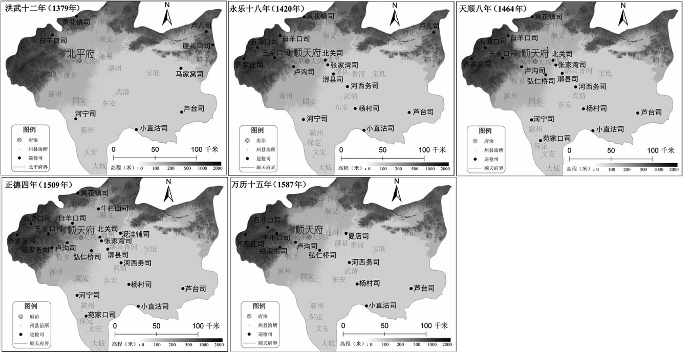
Xunjiansi (Department of Touring and Inspection) was an important organization in charge of keeping order and public security of base-level communities in Ming Dynasty. Shuntian-fu covered not only the capital city and its vicinity, but served as a border stronghold with strategic importance as well. There were 22 Xunjiansi ever set under Shuntian-fu in different periods. By studying the timing of their establishment and revocation, location of their seats, and their relocation history in detail, we noticed that most Xunjiansi clustered near important passes and fortresses along the Great Wall or near important intersections along the Grand Canal. Two most significant clusters of Xunjiansi were on the flank of the capital city. They were located in the mountainous region to the west of Beijing and along the Grand Canal to the east of Beijing respectively. These two lines had great significance for the public safety in western Beijing and river transportation in eastern Beijing, so they received constant high attention from the court. Xunjiansi along these two lines were relatively evenly distributed and stable in long run. The number of Xunjiansi in Shuntian-fu was low during the reign of Hongwu Emperor of early Ming Dynasty. The number began to increase in the reign of Yongle Emperor and the overall distribution pattern of Xunjiansi in Shuntian-fu was thence established. During the late reign of Hongzhi Emperor and early reign of Zhengde Emperor, the number of Xunjiansi in Shuntian-fu reached its peak. After that, the number of Xunjiansi in Shuntian-fu remarkably declined during the reign of Jiajing Emperor because of the empire’s financial difficulties. This led to the gradually weakening control over base-level communities from Xunjiansi.
After the defeat of the Qing Dynasty in the First Sino-Japanese War, Li Hongzhang (1823-1901) was appointed as a special envoy to sign the Treaty of Peace between China and Japan (Treaty of Shimonoseki) with the Japanese. Subsequently, Russia joined by Germany and France demanded that Japan abandon the occupation of the Liaodong Peninsula. This is the famous “Triple Intervention” in modern history. In the 22nd year of the reign of Guangxu Emperor (1896), the Qing court signed the Li-Lobanov Treaty with Russia. In March of the 24th year of the reign of Guangxu Emperor (1898), the Qing court and Russia signed the Convention for the Lease of Liaotung Peninsula between China and Russia, in which the Qing court leased ports of Lushun and Dalian to Russia. In order to prevent the expansion of the Russian sphere of influence, the United Kingdom proposed the lease of Weihaiwei from Qing court. According to historical records from archives, the British careful analyzed and planned, and negotiated with other major powers before the lease of Weihaiwei. Shortly following these, the United Kingdom negotiated with the Qing court for the Weihaiwei lease, and pressured the Qing court to sign the Convention respecting Weihaiwei between China and Great Britainvention for the Lease of Weihaiwei, which made Weihaiwei under British rule. Based on the historical archive, the Archives of the Ministry Foreign Affair of the Qing Dynasty: the British Lease of Weihaiwei and other related historical archives, we intend to provide a preliminary discussion on the negotiation process of the British lease of Weihaiwei by inspecting the original archive of the Convention respecting Weihaiwei between China and Great Britainvention for the Lease of Weihaiwei and related maps in this paper.
Based on studies on the three major places of worldwide origin of agricultural crops, we propose in this paper that China’s most significant contribution to the development of world civilization is domesticating foxtail millet, broomcorn millet and rice. We pay special attention on environmental settings of agriculture’s places of origins and point out that physical environment at those places was not the best. Imperfect environment forces people to give up hunting and gathering and to obtain food through agricultural practices. The excellent natural environment of European plains once provided abundant fauna and flora resources, but it led to a long period of barbarism and impeded the development of civilization. With a geographical perspective, we can see that originations of human civilization were areas with fragile environmental settings.
From the history of salt since Han Dynasty, we can see Chinese people’s curiosity to the rare salt from foreign lands. Salt from multiple originations has bizzare colors that are different from what people from China Proper had been observing and purchasing in their economic production and daily diet. Many scholars consider the “five-color salt” mentioned in the legendary Susha clan’s “boiling sea” as a foreign anecdote. Records like purple, blue, yellow, red and black salt could be found in various documents. These experiences with colored salt from distant places were based on practices of the long-distance transportation. There is also a connection between early memories of the Silk Road and related evidences in the salt history. This connection deserves more attention from researchers in transportation geography and cultural history.
In August 1906, after accepting the military mission from the General Staff Headquarter of Russian Armies, Mannerheim, a Finnish professional soldier, formed a small expedition team to conduct a military reconnaissance from Central Asia to Xinjiang, China. This expedition lasted for one year and two months. Mannerheim later arrived in Beijing and completed the military investigation report (including attached pictures) at the Russian Embassy, and submitted the report to higher authorities. In this paper, we focus on many historical details of this expedition team when they were in Xinjiang. These details include how they focused on the military topography, how they made use of equipment, and how they eventually completed a diary-style book with military intelligence values. After a hundred years, the timeliness of the military intelligence has been greatly reduced, but the report and diary can still be used as valuable historical and geographical accounts for reference.
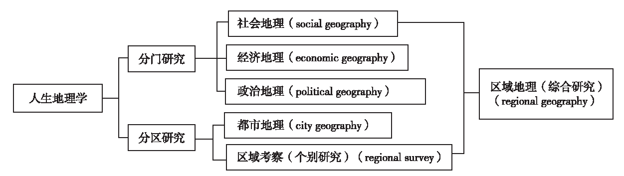
Looking through the development of geography as a subject in China, human geography was once translated into renwen dilixue or rensheng dilixue. The academia can hardly define exact meanings and relationship between these two terms precisely. Interpretation of the literature in the first half of the 20th century helps reveal the evolution of these terminologies. The course of such development should be divided into three stages. In the first stage, renwen dilixue evolved from the convergence between traditional chorography and modern human geography in order to study humanity aspects of geography. In the second stage, rensheng dilixue emerged in order to criticize the traditional chorography and to promote the theory regarding the human-place relationship as the core content of human geography. It was affected by the French school of thoughts. The third stage was, again, renwen dilixue, but with meanings differ from either of previous ones’. It criticized the theory of human-place relationship of the stage two. It was proposed under a general ideological background that combined landscape and dialectical materialism theories. Throughout these three stages, we can notice that the phrase human geography in China had different meanings at different time. Inheritance of those meanings exists, but criticism from one to another dominates. Essentially, these variations of academic thoughts were the result of the introduction of Western modern geographical thoughts that blended with the domestic academic environment and historical background of China.