
龙州开埠与桂越边境交通地理变迁(1889—1932)
|
何斯薇,女,1994年生,广东湛江人,复旦大学历史地理研究中心博士研究生。 |
收稿日期: 2024-01-29
网络出版日期: 2025-03-21
基金资助
教育部规划基金项目“近代中国邮政舆图的整理与研究(1903—1942年)”(22YJA770017)
国家社会科学基金一般项目“近代中国邮政网络的信息可达性研究(1903—1942)”(24BZS087)
用友基金会“商的长城”重点项目“近代商业信息网络的高精度空间复原及可达性分析(1903—1942)”(2023-Z01)
The Opening of Longzhou and the Changes in Transportation Geography along the Guangxi-Vietnam Frontier (1889-1932)
Received date: 2024-01-29
Online published: 2025-03-21
何斯薇 . 龙州开埠与桂越边境交通地理变迁(1889—1932)[J]. 历史地理研究, 2024 , 44(4) : 72 -88 . DOI: 10.20166/j.issn.2096-6822.L20240043
The opening of treaty ports profoundly influences local transportation, commerce, and social change. While existing research often concentrates on ports with significant modernization achievements, there is a dearth of studies exploring the constraints faced by ‘unsatisfactory’ ports in their challenging modernization processes. Longzhou (龙州), located in Guangxi Province and adjacent to northern Vietnam, is situated in a rugged mountainous area at the upper reaches of the Zuojiang (左江), characterized by its treacherous waters and numerous shoals. This study examines the opening of Longzhou and the evolution of transportation geography along the Guangxi-Vietnam border. By analyzing the development of railway, waterway, and highway construction plans and the changes in their leadership, it concludes that geographical positioning was both the catalyst for Longzhou’s opening at certain historical moments and a fundamental, long-term obstacle to improving transportation infrastructure. As a result, Longzhou repeatedly encountered setbacks in trade route competition, reflecting the substantial historical inertia of the natural geographical environment and the intricate power struggles among various forces in the Guangxi-Vietnam border region under fluctuating political circumstances.
Key words: Longzhou; Zuojiang River Basin; port opening; transportation geography
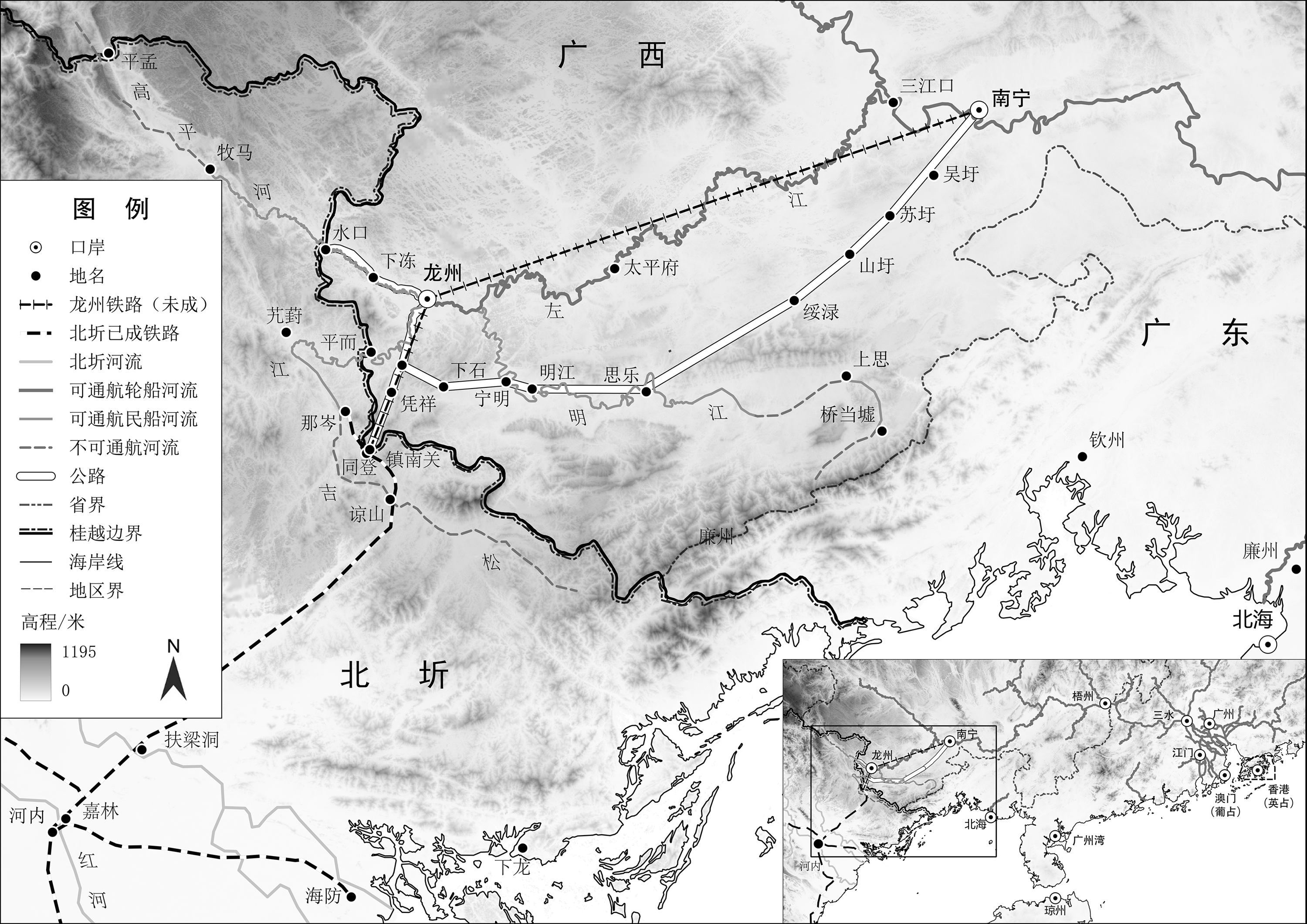
图1 1932年桂越边境交通示意资料来源: 底图为CHGIS(V6)的1911年层数据, https://chgis.fairbank.fas.harvard.edu/data/chgis/v6/;国界数据来自中国科学院资源环境科学与数据中心的“全球国家行政边界数据”,https://www.resdc.cn/data.aspx?DATAID=205;DEM数据是根据SRTM 30M数据自行合成的全球250M数据, https://mp.weixin.qq.com/s/jOK4p-m2aQMjPpCOLideuw。 |
表1 1897年西江线和海防线运输成本对比表 (单位: 元) |
| 西江线 | 香港—梧州 | 梧州—南宁 | 关税 | 合计 | ||||||
|---|---|---|---|---|---|---|---|---|---|---|
| 交通工具 | 运 费 | 交通工具 | 运 费 | |||||||
| 棉纱 | 轮船 | 1.25 | 民船 | 0.8 | 4.8 | 6.85 | ||||
| 煤油 | 轮船 | 0.2 | 民船 | 0.2 | 0.17 | 0.57 | ||||
| 海防线 | 海防—扶梁洞 | 扶梁洞—谅山 | 谅山—龙州 | 龙州—南宁 | 关税 | 合计 | ||||
| 交通工具 | 运费 | 交通工具 | 运费 | 交通工具 | 运费 | 交通工具 | 运费 | |||
| 棉纱 | 轮船 | 0.3 | 火车 | 3.4 | 未定 | 未定 | 民船 | 0.45 | 3.85 | >8 |
| 煤油 | 轮船 | 0.1 | 火车 | 0.6 | 未定 | 未定 | 民船 | 0.1 | 0.17 | >0.97 |
资料来源: 《光绪二十三年(1897)龙州口华洋贸易情形论略》,《中国旧海关史料》第26册,第254页。 注: 以棉纱每包重300斤、煤油每箱重60斤计算。 |
/
| 〈 |
|
〉 |
