
|
户传琦,女,1997年生,内蒙古牙克石人,陕西师范大学西北历史环境与经济社会发展研究院硕士研究生; |
|
王社教,男,1965年生,安徽桐城人,博士,陕西师范大学西北历史环境与经济社会发展研究院教授,主要从事历史地理学研究; |
|
楼烨扬,男,1999年生,浙江杭州人,索邦大学文学院(Sorbonne UniversitÉ, FacultÉ des Lettres)硕士研究生。 |
收稿日期: 2023-09-15
网络出版日期: 2025-05-20
基金资助
国家社会科学基金冷门绝学研究专项学术团队项目“陕西古旧地图整理与研究”(20VJXT003)
Longitude and Latitude Measurement Activities in the Shanxi and Shaanxi Region During the Kangxi Period
Received date: 2023-09-15
Online published: 2025-05-20
户传琦 , 王社教 , 楼烨扬 . 康熙年间山陕地区三次经纬度测量活动考述[J]. 历史地理研究, 2025 , 45(1) : 100 -114 . DOI: 10.20166/j.issn.2096-6822.L20230319
This article examines the process of three longitude and latitude measurement activities conducted in the Shanxi and Shaanxi regions during the Kangxi period and analyzes the sources and complexity of the data in the longitude and latitude tables appended to the Description of China (《中华帝国全志》). Firstly, it reviews the courses of the three measurements carried out in 1697, 1708, and 1712-1713, and reconstructs parts of the measurement routes. Secondly, it outlines the compilation process and different versions of the longitude and latitude tables in the Description of China. Finally, by comparing the similarities and differences between the tables in the Description of China and the results of the three measurements, it reveals the complexity of the data sources for these tables.
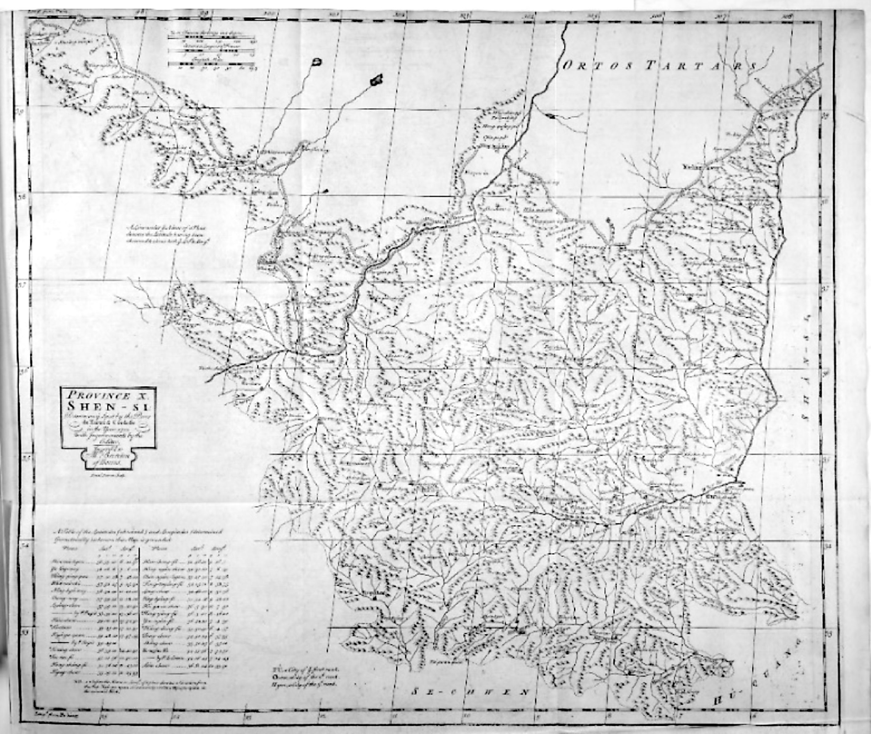
表1 1697年山陕地区第一次经纬度测量活动的途经地点与观测值 |
| 山西行迹与观测值 | 陕西行迹与观测值 | ||||
|---|---|---|---|---|---|
| 时间 | 途经地点 | 观测纬度值 | 时间 | 途经地点 | 观测纬度值 |
| 3月6日 | 天城 | 3月21—23日 | 府谷县 | 39°09' | |
| 3月7日 | 阳和城 | 3月24日 | 孤山堡 | 39°15' | |
| 3月8日 | 聚乐堡 | 3月25日 | 镇羌堡、卞家水口 | 39°20'(卞家水口) | |
| 3月9—10日 | 大同府 | 40°16' | 3月26日 | 永兴堡、神木县 | 39°08'(神木县) |
| 3月11日 | 怀仁县 | 3月27日 | 窟野河 | ||
| 3月12日 | 郑家庄 | 3月28日 | 柏林堡 | 38°55' | |
| 3月13日 | 榆林村 | 3月29日 | 高家堡 | 38°46' | |
| 3月14日 | 马邑、朔州 | 39°28'(朔州) | 3月30日 | 建安堡 | 38°41' |
| 3月15日 | 大水口堡 | 39°21' | 3月31日 | 双山堡 | 38°35' |
| 3月16日 | 神池、义井 | 39°18'(义井) | 4月1日 | 榆林卫 | 38°26' |
| 3月17日 | 三岔堡 | 39°21' | 4月8—9日 | 安边城 | |
| 3月18日 | 李家沟 | 4月10日 | 砖井堡、定边 | 37°36'(定边) | |
| 3月19日 | 辇鄢村 | 4月11日 | 盐场堡、花马池 | 37°35'(花马池) | |
| 3月20日 | 保德州 | 39°08' | 4月12日 | 高平堡、安定堡 | 38°04'(安定堡) |
| 4月13日 | 兴武营 | ||||
| 4月14日 | 毛卜剌堡、清水营 | 38°21'(清水营) | |||
| 4月15日 | 红山堡、横城 | ||||
| 4月16日 | 河崖38°30' | ||||
| 4月17日— 5月4日 | 宁夏卫 | 38°35' | |||
| 5月5日 | 尧甫堡 | ||||
| 5月6日 | 流穆河西岸 | ||||
| 5月7日 | 哨马营西南隅 之峡河西岸 | ||||
| 5月8日 | 哨马营 | ||||
| 5月9—10日 | 石嘴子 | ||||
图1 《中华帝国全志》“第十省·陕西”(Province X Shen-Si)图资料来源: J. B. Du Halde,A Description of the Empire of China and Chinese-Tartart Together With the Kingdoms of Korea, and Tibet: Containing The Geography and History (Natural As Well As Civil) of Those Countries, Volume 1, London: Edward Cave, 1738, pp.108-109。此图系1708—1713年间测绘而成,反映陕甘未分省前情况。 |
表2 山陕地区观测纬度值与《全志》经纬度表对比 |
| 地 点 | 1697年 观测纬度值 | 1708年 观测纬度值 | 1712年 观测纬度值 | 《全志》经纬度 表纬度值 | 《康图》纬度值 |
|---|---|---|---|---|---|
| 大同府 | 40°16' | 40°05'42″ | 40°04'52″ | ||
| 朔州 | 39°28' | 39°25'12″ | 39°25'54″ | ||
| 保德州 | 39°08' | 39°04'44″ | 39°04'45″ | ||
| 杀虎口 | 40°20'00″④ | 40°17'00″ | 40°16'35″ | ||
| 神木县 | 39°08'00″ | 38°55'20″ | 38°55'20″ | 38°55'23″ | |
| 榆林卫 | 38°26'00″ | 38°15'08″ | 38°18'08″ | 38°18'16″ | |
| 清平堡 | 37°42'40 | ″37°40'48″ | 37°40'20″ | ||
| 花马池 | 37°35'00″ | 37°52'45″ | 37°52'45″ | 37°51'43″ | |
| 宁夏卫 | 38°35'00″ | 38°32'40″ | 38°32'40″ | 38°32'49″ | |
| 中卫 | 37°40'45″ | 37°39'35″ | 37°39'41″ | ||
| 凉州 | 37°59'00″ | 37°59'00″ | 37°58'37″ | ||
| 甘州 | 39°00'40″ | 39°00'40″ | 39°00'02″ | ||
| 肃州 | 39°45'20″ | 39°45'40″ | 39°44'14″ | ||
| 嘉峪关 | 39°49'20″ | 39°48'20″ | 39°47'04″ | ||
| 兰州 | 36°08″00″ | 36°08'24″ | 36°06'53″ | ||
| 西宁府 | 36°39'00″ | 36°39'20″ | 36°39'28″ | ||
| 临洮府 | 35°19'46″ | 35°21'36″ | 35°20'58″ |
注: 灰色表示有相同数值,下同。 |
表3 山陕地区观测经度值与《全志》经纬度表对比 |
| 地 点 | 1697年观测经度值 | 1708年观测经度值 | 《全志》经纬度表经度值 | 《康图》经度值 |
|---|---|---|---|---|
| 杀虎口 | 04°12'00″/04°15'00″① | 4°10' | 04°12'00″ | 04°10'58″ |
| 神木县 | 06°25'00″ | 06°22'30″ | 06°25'35″ | |
| 榆林卫 | 07°07'00″ | 07°06'00″ | 07°6'50″ | |
| 宁夏卫 | ||||
| 凉州 | 13°43'00″ | 13°40'30″ | 13°43'40″ | |
| 嘉峪关 | 17°56'00″ | 17°37'45″ | 17°39'33″ | |
| 西宁府 | 14°34'00″/14°35'00″ | 14°40'30″ | 14°42'38″ |
表4 1733年以前洪若翰、李明所测经纬度与《全志》经纬度表对比 |
| 地点 | 《全志》经纬度表纬度 | 洪若翰所测纬度 | 李明所测纬度 | 《全志》经纬度表经度 | 李明所测经度 |
|---|---|---|---|---|---|
| 西安 | 34°15'36″ | 34°16'26″ | 34°16'45″⑤中记,李明神甫所测西安纬度为34°16′45″,经度为7°14′45″。) | 07°34'30″ | 7°14'45″ |
| 34°16'33″ | 7°39'45″⑥ |
/
| 〈 |
|
〉 |
